Vous pouvez marquer votre extraits intéressants de texte qui seront disponibles par le biais d'un lien unique dans votre navigateur.

Binnenmaas

Binnenmaas
Binnenmaas
Blason de Binnenmaas
Héraldique
Drapeau de Binnenmaas
Drapeau

Administration
Pays Drapeau : Pays-Bas Pays-Bas
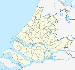
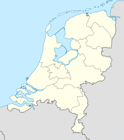
Province Hollande-Méridionale
Code postal 3271, 3273-4, 3295, 3297, 3299
Géographie
Coordonnées 51° 49′ 01″ N 4° 31′ 01″ E / 51.817, 4.51751° 49′ 01″ Nord
       4° 31′ 01″ Est
/ 51.817, 4.517
  
Superficie 7 560 ha = 75,60 km2
  - Terre 6 926 ha = 69,26 km2
  - Eau 634 ha = 6,34 km2
Démographie
Population 19 614 hab.
Densité 379 hab./km2
Localisation
Localisation de Binnenmaas

Géolocalisation sur la carte : Hollande-Méridionale

(Voir situation sur carte : Hollande-Méridionale)
Binnenmaas

Géolocalisation sur la carte : Pays-Bas

(Voir situation sur carte : Pays-Bas)
Binnenmaas
Lac Binnenmaas

Binnenmaas est une commune néerlandaise, en province de Hollande-Méridionale.

La commune a été créée le 1er janvier 1984 par la fusion des communes de Maasdam, Heinenoord, Puttershoek, Mijnsheerenland et Westmaas. Son nom vient de la Binnenbedijkte Maas, un tracé ancien de la Meuse aujourd'hui complètement séparé du cours d'eau. Le 1er janvier 2007, la commune de 's-Gravenland a été rattachée à Binnenmaas.

Lien externe

(nl) Site officiel

Sur les autres projets Wikimedia :


Wikimedia Foundation. 2010.

  
Share  

Regardez d'autres dictionnaires:

  • Binnenmaas — Gemeinde Binnenmaas Flagge Wappen Provinz Südholland Bürgermeister …   Deutsch Wikipedia

  • Binnenmaas — Infobox Settlement official name = Binnenmaas flag size = 120x100px image shield = Coat of arms of Binnenmaas.png shield size = 120x100px mapsize = 280px subdivision type = Country subdivision name = Netherlands subdivision type1 = Province… …   Wikipedia

  • Maasdam — Gemeinde Binnenmaas Flagge Wappen Provinz Südholland …   Deutsch Wikipedia

  • Puttershoek — Gemeinde Binnenmaas Flagge Wappen Provinz Südholland …   Deutsch Wikipedia

  • Liste der ehemaligen Gemeinden in Südholland — Hierunter folgt eine Liste der ehemaligen südholländischen Gemeinden. Wenn das Gebiet einer aufgehobenen Gemeinde über mehrere Gemeinden verteilt worden ist, ist das Großteil der erstgenannten Gemeinde hinzugefügt. Grenzkorrekturen zwischen… …   Deutsch Wikipedia

  • Mijnsheerenland — 51°47′47″N 4°28′59″E / 51.79639, 4.48306 …   Wikipédia en Français

  • Maasdam — 51°47′17″N 4°33′22″E / 51.78806, 4.55611 …   Wikipédia en Français

  • Puttershoek — is a town in The Netherlands, in the province of South Holland, on the banks of the Oude Maas river, part of the Binnenmaas municipality, on the Hoeksche Waard island. The town (the largest one of the municipality) has a city like character with… …   Wikipedia

  • Heinenoord — is a town in the Dutch province of South Holland. It was located about 10 km south of Rotterdam, in the municipality of Binnenmaas.Heinenoord was a separate municipality until 1984, when it became part of Binnenmaas. After 1855, the municipality… …   Wikipedia

  • Maasdam — is a village in the Dutch province of South Holland. It is located about 14 km south of the city of Rotterdam, in the municipality of Binnenmaas.Maasdam was a separate municipality until 1984, when it became part of Binnenmaas. [Ad van der Meer… …   Wikipedia