Solčany
- Solčany
-
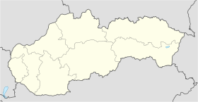
Šalgovce (allemand : Salgowitz, hongrois : Tótsók)[4] est un village de Slovaquie situé dans la région de Nitra.
Histoire
Première mention écrite du village en 1156.
Notes et références
Catégories :
- Village de Slovaquie
- Village et ville du district de Topoľčany
Wikimedia Foundation.
2010.
Contenu soumis à la licence CC-BY-SA. Source : Article Solčany de Wikipédia en français (auteurs)
Regardez d'autres dictionnaires:
Solčany — Wappen Karte … Deutsch Wikipedia
Solčany — is a municipality in the Topoľčany District of the Nitra Region, Slovakia … Wikipedia
Anton Ondrus — Anton Ondruš Spielerinformationen Geburtstag 27. März 1950 Geburtsort Solčany, Tschechoslowakei Position Abwehrspieler Vereine in der Jugend 1959–1970 Slovan Bratislava … Deutsch Wikipedia
Anton Ondruš — Anton Ondruš Spielerinformationen Geburtstag 27. März 1950 Geburtsort Solčany, Tschechoslowakei Position Abwehrspieler Vereine in der Jugend … Deutsch Wikipedia
District de Topoľčany — 48°33′30″N 18°12′24″E / 48.55833, 18.20667 … Wikipédia en Français
Nitra Region — Coordinates: 48°18′25″N 18°05′11″E / 48.30694°N 18.08639°E / 48.30694; 18.08639 … Wikipedia
Topoľčany — Coordinates: 48°33′15″N 18°10′37″E / 48.55417°N 18.17694°E / 48.55417; 18.17694 … Wikipedia
Topoľčany District — District Country Slovakia Region … Wikipedia
Anton Ondruš — (born 27 March, 1950 in Solčany, Czechoslovakia) is a former Slovak football player. He played 58 matches for Czechoslovakia and scored 9 goals. He was a participant at the 1976 UEFA European Championship, where Czechoslovakia won the gold medal … Wikipedia
List of municipalities and towns in Slovakia — Slovakia This is a comprehensive list of municipalities and towns in Slovakia. For lists of towns and municipalities sorted by Regions see the individual articles on Regions. For an outdated list of towns only in Slovakia see also List of towns… … Wikipedia
 Slovaquie
 Šalgovce