Giethmen
Contenu soumis à la licence CC-BY-SA. Source : Article Giethmen de Wikipédia en français (auteurs)
Regardez d'autres dictionnaires:
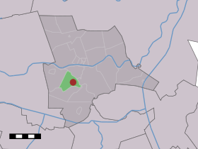
Giethmen — Dutch town locator maps mun town caption = The village (dark red) and the statistical district (light green) of Giethmen in the municipality of Ommen.Giethmen (coord|52|30|N|6|24|E|type:city(170)) is a village in the Dutch province of Overijssel … Wikipedia
Nijhoff — (Giethmen,Нидерланды) Категория отеля: 3 звездочный отель Адрес: 8147RJ Giethmen, Нидерланды … Каталог отелей
Vakantieboerderij B&B De Luttikhoeve — (Giethmen,Нидерланды) Категория отеля: Адрес: Koedijk 3, 8147 … Каталог отелей
Ommen — Municipality The Sahara near Ommen … Wikipedia
List of places in the Netherlands — This is an alphabetical list of places (cities, towns, villages) in the Netherlands. Lists per province can be found at:* List of towns in Groningen * List of towns in Friesland * List of towns in Drente * List of towns in Overijssel * List of… … Wikipedia
Arriën — 52°31′37″N 6°26′59″E / 52.52694, 6.44972 … Wikipédia en Français
Beerze (Overijssel) — 52°30′49″N 6°31′43″E / 52.51361, 6.52861 … Wikipédia en Français
Beerzerveld — 52°29′38″N 6°34′36″E / 52.49389, 6.57667 … Wikipédia en Français
Dalmsholte — 52°28′32″N 6°21′54″E / 52.47556, 6.365 … Wikipédia en Français
Lemele — 52°27′8″N 6°24′53″E / 52.45222, 6.41472 … Wikipédia en Français
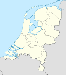

 Pays-Bas