Stegeren
Contenu soumis à la licence CC-BY-SA. Source : Article Stegeren de Wikipédia en français (auteurs)
Regardez d'autres dictionnaires:
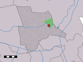
Stegeren — Dutch town locator maps mun town caption = The village (dark red) and the statistical district (light green) of Stegeren in the municipality of Ommen.Stegeren (coord|52|31|N|6|31|E|type:city(170)) is a village in the Dutch province of Overijssel … Wikipedia
Huisje Arti — (Stegeren,Нидерланды) Категория отеля: 2 звездочный отель Адрес: 7737PE Stegeren, Нидерл … Каталог отелей
Ommen — Municipality The Sahara near Ommen … Wikipedia
List of places in the Netherlands — This is an alphabetical list of places (cities, towns, villages) in the Netherlands. Lists per province can be found at:* List of towns in Groningen * List of towns in Friesland * List of towns in Drente * List of towns in Overijssel * List of… … Wikipedia
Radio 105 (Italy) — Infobox Radio station name = Radio 105 area = flagicon|Italy Italy FM frequencies in Italy and Monaco, DAB, DVB T, DVB H, DVB S on Hotbird and worldwide with internet streaming airdate = 1976 frequency = several frequencies, change from… … Wikipedia
Arriën — 52°31′37″N 6°26′59″E / 52.52694, 6.44972 … Wikipédia en Français
Beerze (Overijssel) — 52°30′49″N 6°31′43″E / 52.51361, 6.52861 … Wikipédia en Français
Beerzerveld — 52°29′38″N 6°34′36″E / 52.49389, 6.57667 … Wikipédia en Français
Dalmsholte — 52°28′32″N 6°21′54″E / 52.47556, 6.365 … Wikipédia en Français
Giethmen — 52°29′30″N 6°24′20″E / 52.49167, 6.40556 … Wikipédia en Français
 Pays-Bas