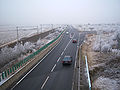
Guntersblum
Contenu soumis à la licence CC-BY-SA. Source : Article Guntersblum de Wikipédia en français (auteurs)
Regardez d'autres dictionnaires:
Guntersblum — Guntersblum, Gemeinde im Landkreis Mainz Bingen, Rheinland Pfalz, 4 000 Einwohner; Weinbau. Stadtbild: Im Ortskern das barocke Neue Schloss, Adelshöfe und das Deutschordenshaus. Die evangelische Pfarrkirche (ehemali … Universal-Lexikon
Guntersblum — Guntersblum, Marktflecken im Kreise Oppenheim der großherzoglich hessischen Provinz Rheinhessen, unweit des Rheins; Station der hessischen Ludwigsbahn, gräflich Leiningen Billigheimisches Schloß, evangelische u. katholische Kirche, Synagoge,… … Pierer's Universal-Lexikon
Guntersblum — Guntersblum, Flecken in der hess. Provinz Rheinhessen, Kreis Oppenheim, Knotenpunkt der preußisch hessischen Staatsbahnlinien Mainz Worms und Osthofen G., hat eine evangelische und eine kath. Kirche, Synagoge, Schloß des Grafen von Leiningen,… … Meyers Großes Konversations-Lexikon
Guntersblum — Guntersblum, großherz. hess. Stadt am Rhein mit 2600 E., einer Synagoge, Weinbau … Herders Conversations-Lexikon
Guntersblum — Wappen Deutschlandkarte … Deutsch Wikipedia
Guntersblum — Infobox Ort in Deutschland image photo = Wappen = Wappen von Guntersblum.png lat deg = 49 |lat min = 47 |lat sec = 50 lon deg = 8 |lon min = 20 |lon sec = 44 Lageplan = Bundesland = Rheinland Pfalz Landkreis = Mainz Bingen Verbandsgemeinde =… … Wikipedia
Guntersblum — Original name in latin Guntersblum Name in other language Guntersblum, gong te er si bu lu mu, Гунтерсблум State code DE Continent/City Europe/Berlin longitude 49.7975 latitude 8.34556 altitude 94 Population 3702 Date 2011 04 25 … Cities with a population over 1000 database
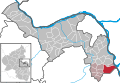
Guntersblum (Verbandsgemeinde) — Guntersblum est une Verbandsgemeinde (collectivité territoriale) de l arrondissement de Mayence Bingen dans la Rhénanie Palatinat en Allemagne. Le siège de cette Verbandsgemeinde est dans la ville de Guntersblum. La Verbandsgemeinde de… … Wikipédia en Français
Guntersblum (Verbandsgemeinde) — Guntersblum is a Verbandsgemeinde ( collective municipality ) in the district Mainz Bingen in Rhineland Palatinate, Germany. The seat of the Verbandsgemeinde is in Guntersblum.The Verbandsgemeinde Guntersblum consists of the following… … Wikipedia
St. Viktor (Guntersblum) — Die Guntersblumer evangelische Kirche von Süden aus Die Kirche St. Viktor in der rheinhessischen Ortsgemeinde Guntersblum ist eine heutige evangelische Kirche mit langer Geschichte. Das Bauwerk gilt heute als Kulturdenkmal … Deutsch Wikipedia

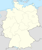

 Allemagne