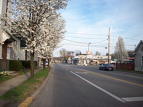
Ceredo

Ceredo

38° 23′ 36″ N 82° 33′ 37″ W / 38.393333, -82.560278

Ceredo
Image illustrative de l'article Ceredo
Administration
Pays Drapeau des États-Unis États-Unis
État Virginie-Occidentale Virginie-Occidentale
Comté Wayne
Maire Otis Adkins
Code FIPS 54-14308
GNIS 1537176
Site web Consulter
Historique
Fondation 1857
Démographie
Population (2000) 1 675 hab.
Densité 322 hab./km²
Géographie
Coordonnées 38° 23′ 36″ Nord
       82° 33′ 37″ Ouest
/ 38.393333, -82.560278
Altitude 168 m
Superficie totale 5,2 km2
· dont terre 3,5 km2 (67,31 %)
· dont eau 1,7 km2 (32,69 %)
Fuseau horaire EST (UTC-5)
Voir la carte administrative
City locator 14.svg
Voir la carte topographique
City locator 14.svg

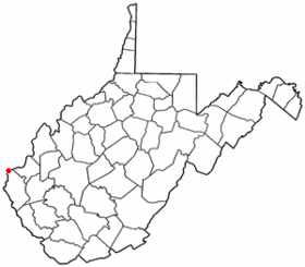
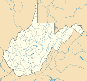
Ceredo est une ville située sur les rives de la rivière Ohio, dans le comté de Wayne, dans l’État de Virginie-Occidentale, aux États-Unis. Lors du recensement de 2000, sa population s’élevait à 1 675 habitants. Sa superficie totale est de 5,2 km² (2 mi²). Coordonnées géographiques : 38°23′36″N 82°33′37″O / 38.39333, -82.56028.

Fondée en 1857, la ville fait partie de l’agglomération de Huntington (Virginie-Occidentale)-Ashland (Kentucky).

Source


Wikimedia Foundation. 2010.

Contenu soumis à la licence CC-BY-SA. Source : Article Ceredo de Wikipédia en français (auteurs)

Игры ⚽ Нужно решить контрольную?

Regardez d'autres dictionnaires:

  • Ceredo — Ceredo, WV U.S. city in West Virginia Population (2000): 1675 Housing Units (2000): 888 Land area (2000): 1.343781 sq. miles (3.480377 sq. km) Water area (2000): 0.678723 sq. miles (1.757885 sq. km) Total area (2000): 2.022504 sq. miles (5.238262 …   StarDict's U.S. Gazetteer Places

  • Ceredo, WV — U.S. city in West Virginia Population (2000): 1675 Housing Units (2000): 888 Land area (2000): 1.343781 sq. miles (3.480377 sq. km) Water area (2000): 0.678723 sq. miles (1.757885 sq. km) Total area (2000): 2.022504 sq. miles (5.238262 sq. km)… …   StarDict's U.S. Gazetteer Places

  • Ceredo — Original name in latin Ceredo Name in other language State code US Continent/City America/New York longitude 38.39647 latitude 82.55877 altitude 168 Population 1450 Date 2011 05 14 …   Cities with a population over 1000 database

  • Ceredo, West Virginia —   City   Looking east along U.S. Route 60 from C Street …   Wikipedia

  • 25507 — Ceredo, Wv (Miscellaneous » ZIP Codes) …   Abbreviations dictionary

  • List of cities and towns along the Ohio River — This is a list of cities, towns and communities along the Ohio River in the United States.Alphabetically*Aberdeen, Ohio *Addyston, Ohio *Aliquippa, Pennsylvania *Alton, Indiana *Ambridge, Pennsylvania *Ashland, Kentucky *Athalia, Ohio *Augusta,… …   Wikipedia

  • Mitch Stadium — The Mitch Location 600 Poplar Street Kenova, WV 25530 Broke ground 1955 Opened April …   Wikipedia

  • Dagmar (American actress) — For other uses, see Dagmar (disambiguation). Dagmar Alfred Eisenstaedt photographed Dagmar for the July 16, 1951 issue of Life Born Virginia Ruth Egnor November 29, 1921 …   Wikipedia

  • Huntington, West Virginia — City of Huntington, West Virginia   City   Huntington s Central Business District as seen from the Robert C. Byrd Bridge at 6th Street …   Wikipedia

  • Kenova, West Virginia — Infobox Settlement official name = Kenova, West Virginia settlement type = City nickname = motto = imagesize = image caption = image mapsize = 250x200px map caption = Location of Kenova, West Virginia mapsize1 = map caption1 = subdivision type =… …   Wikipedia

Share the article and excerpts

Direct link
Do a right-click on the link above
and select “Copy Link”