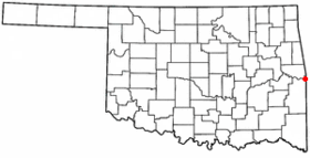
Arkoma
Contenu soumis à la licence CC-BY-SA. Source : Article Arkoma de Wikipédia en français (auteurs)
Regardez d'autres dictionnaires:
Arkoma — Arkoma … Deutsch Wikipedia
Arkoma — Arkoma, OK U.S. town in Oklahoma Population (2000): 2180 Housing Units (2000): 975 Land area (2000): 3.512130 sq. miles (9.096374 sq. km) Water area (2000): 0.081671 sq. miles (0.211526 sq. km) Total area (2000): 3.593801 sq. miles (9.307900 sq.… … StarDict's U.S. Gazetteer Places
Arkoma, OK — U.S. town in Oklahoma Population (2000): 2180 Housing Units (2000): 975 Land area (2000): 3.512130 sq. miles (9.096374 sq. km) Water area (2000): 0.081671 sq. miles (0.211526 sq. km) Total area (2000): 3.593801 sq. miles (9.307900 sq. km) FIPS… … StarDict's U.S. Gazetteer Places
Arkoma — Original name in latin Arkoma Name in other language State code US Continent/City America/Chicago longitude 35.35454 latitude 94.4341 altitude 160 Population 1989 Date 2011 05 14 … Cities with a population over 1000 database
Arkoma, Oklahoma — Infobox Settlement official name = Arkoma, Oklahoma settlement type = Town nickname = motto = imagesize = image caption = image mapsize = 250px map caption = Location of Arkoma, Oklahoma mapsize1 = map caption1 = subdivision type = Country… … Wikipedia
74901 — Arkoma, Ok (Miscellaneous » ZIP Codes) … Abbreviations dictionary
Oklahoma State Highway 112 — State Highway 112 Route information … Wikipedia
National Register of Historic Places listings in Le Flore County, Oklahoma — Location of Le Flore County in Oklahoma This is a list of the National Register of Historic Places listings in Le Flore County, Oklahoma. This is intended to be a complete list of the properties and districts on the National Register of Historic… … Wikipedia
Shale gas — may also refer to gas generated from oil shaleShale gas is natural gas produced from shale. Because shales ordinarily have insufficient permeability to allow significant fluid flow to a well bore, most shales are not sources of natural gas. Shale … Wikipedia
List of high schools in Oklahoma — This is a list of high schools in the state of Oklahoma.Adair County*Cave Springs Public Schools **Cave Springs High School, Bunch *Stilwell High School, Stilwell *Watts High School, Watts *Westville High School, WestvilleAlfalfa County*Aline… … Wikipedia
 États-Unis
 Oklahoma