East Hereford
- East Hereford
-
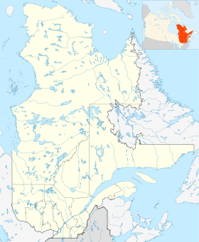
East Hereford est une municipalité du Québec, située dans la MRC de Coaticook en Estrie[1].
Situation
« La municipalité d'East Hereford a été constituée en 1855. Elle couvre une superficie de 71,56 kilomètres carrés, près de la frontière américaine »[2].
Toponyme
« Le canton de Hereford ayant été proclamé en 1800, une municipalité devait être créée en 1845 sous une dénomination identique. Abolie en 1847, elle devait être rétablie en 1855 sous le statut de municipalité de canton. Entre 1855 et 1986, la municipalité de canton a subi bien des amputations, quelques désignations ayant retenu la forme Hereford, dont Saint-Venant-de-Hereford. Cette appellation a été modifiée en 1986 par l'ajout du point cardinal East, lequel figurait depuis 1853 dans le nom du bureau de poste local et qui marque la position de l'entité dans la partie est du canton, et par la substitution du statut de municipalité sans autre désignation à celui de municipalité de canton. L'une et l'autre entités font allusion à une ville et à un comté homonymes de l'Angleterre »[3].
Démographie
Le recensement révisé de 2006 y dénombre 349 habitants, soit 8 % de plus qu'en 2001[4],[5].
Références
Lien externe
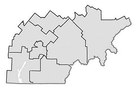
Municipalités limitrophes
Wikimedia Foundation.
2010.
Contenu soumis à la licence CC-BY-SA. Source : Article East Hereford de Wikipédia en français (auteurs)
Regardez d'autres dictionnaires:
East Hereford, Quebec — East Hereford is a village of 300 people in southeastern Quebec, Canada, in the Coaticook Regional County Municipality.East Hereford is located just north over the Beecher Falls , Vermont USA border and on the east side of East Hereford it is… … Wikipedia
Hereford and South Herefordshire (UK Parliament constituency) — Hereford and South Herefordshire County constituency for the House of Commons Boundary of Hereford and South … Wikipedia
Hereford and Worcester — Geography Status Non metropolitan county HQ Worcester … Wikipedia
Hereford United v Newcastle United 1972 — Hereford United v Newcastle United was a football match played on 5 February 1972 at Edgar Street, Hereford. The match was an FA Cup Third Round Replay after the first match had resulted in a 2 ndash;2 draw. The result, a 2 ndash;1 extra time… … Wikipedia
Hereford Castle — was a castle in the cathedral city of Hereford (gbmapping|SO511396) in Herefordshire. Pre Norman Castle It stood on a site to the south and east of the modern city overlooking the River Wye. It is thought that the first castle on the site was a… … Wikipedia
Hereford, Pennsylvania — is an unincorporated community located on Pennsylvania Route 100 and Pennsylvania Route 29 in Hereford Township, Berks County, Pennsylvania with a zip code of 18056. These two highways split off at Hereford, Route 100 heads toward Pottstown,… … Wikipedia
East Point Light — Location Rural Cumberland County, near Heislerville, New Jersey Coordinates … Wikipedia
Hereford Cathedral — Infobox UK cathedral building name =Hereford Cathedral infobox width = image size = caption =Hereford Cathedral from the north map type = map size = map caption = location = full name =Cathedral Church of Blessed Virgin Mary and St Ethelbert geo … Wikipedia
Hereford High School, Parkton — Infobox Secondary school name = Hereford High School native name = motto = established = 1954 type = Public high school category label = category = gender label = gender = affiliations = affiliation = president = chairman label = chairman =… … Wikipedia
Hereford — infobox UK place country = England official name= Hereford latitude= 52.0565 longitude= 2.7160 civil parish= Hereford population = 50,400 [cite web | url= http://www.hereford.gov.uk/Current Hereford City Area Profile.pdf | format= PDF | work=… … Wikipedia
 Canada
 Québec