Myasnikyan
- Myasnikyan
-
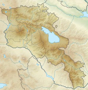
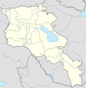
40° 10′ 39″ N 43° 54′ 23″ E / 40.1775, 43.906389
Myasnikyan (en arménien Մյասնիկյան) est une communauté rurale du marz d'Armavir, en Arménie. Elle compte 4 523 habitants en 2009[2].
Notes et références
- ↑ (hy+en) Central Electoral Commission of the Republic of Armenia. Consulté le 24 janvier 2011.
Pour obtenir la page en anglais, cliquez sur le drapeau arménien en haut à gauche, et sélectionnez « English » ; ensuite, dans le menu vertical de gauche, cliquez sur « Local », sélectionnez le
marz pertinent, puis la dernière élection correspondant à la communauté voulue.
- ↑ (en) ArmStat, Marzes of the Republic of Armenia in figures, « RA Armavir Marz », 2009. Consulté le 13 décembre 2009.
Wikimedia Foundation.
2010.
Contenu soumis à la licence CC-BY-SA. Source : Article Myasnikyan de Wikipédia en français (auteurs)
Regardez d'autres dictionnaires:
Myasnikyan — Մյասնիկյան … Wikipedia
Myasnikyan — Original name in latin Myasnikyan Name in other language Mjasnikjan, Myasnikyan, Мясникян State code AM Continent/City Asia/Yerevan longitude 40.1775 latitude 43.90639 altitude 917 Population 3458 Date 2012 01 19 … Cities with a population over 1000 database
List of places named after people — There are a number of places named after famous people. For more on the general etymology of place names see toponomy. For other lists of eponyms (names derived from people) see eponym.Continents*Americas (North America and South America) ndash;… … Wikipedia
Matenadaran — Coordinates: 40°11′31″N 44°31′16″E / 40.19207°N 44.52113°E / 40.19207; 44.52113 … Wikipedia
Red Army — This article is about the 1918 1946 Workers Peasants Red Army. For other uses, see Red Army (disambiguation). Soviet Armed Forces … Wikipedia
Yerevan — For other uses, see Yerevan (disambiguation). Coordinates: 40°11′00″N 44°31′00″E … Wikipedia
Nor Hachn — Coordinates: 40°18′07″N 44°34′59″E / 40.30194°N 44.58306°E / 40.30194; 44.58306 … Wikipedia
Martuni, Armenia — For the village of the same name located on the northern side of Lake Sevan, see Martuni (village). Martuni Մարտունի Martuni at dusk … Wikipedia
Artemi Ayvazyan — Artemi (Harutyun) Ayvazyan ( hy. Արտեմի Այվազյան, ru. Артемий Айвазян, 1902, Baku 1975, Yerevan) was a Soviet Armenian composer, conductor, founder of the Armenian State Jazz Orchestra, and People s Artist of Armenia (1962).Ayvazyan was born in… … Wikipedia
Armavir (Arménie) — Pour les articles homonymes, voir Armavir. 40° 04′ 48″ N 44° 03′ 19″ E / … Wikipédia en Français
 Arménie