Mesterszállás
- Mesterszállás
-
Mesterszállás est un village et une commune du comitat de Jász-Nagykun-Szolnok en Hongrie.
Géographie
Cette section est vide, insuffisamment détaillée ou incomplète.
Votre aide est la bienvenue !
Histoire
Cette section est vide, insuffisamment détaillée ou incomplète.
Votre aide est la bienvenue !
Catégorie :
- Ville et village du comitat de Jász-Nagykun-Szolnok
Wikimedia Foundation.
2010.
Contenu soumis à la licence CC-BY-SA. Source : Article Mesterszállás de Wikipédia en français (auteurs)
Regardez d'autres dictionnaires:
Mesterszállás — Country Hungary County Jász Nagykun Szolnok Area – Total 42.92 km2 ( … Wikipedia
Mezőtúr — Town hall … Wikipedia
Nagyrév — Country Hungary County Jasz Nagykun Szolnok Area – Total 29.79 km2 (11.5� … Wikipedia
Jász-Nagykun-Szolnok County — Infobox Hungarian county name =Jász Nagykun Szolnok region =Northern Great Plain seat = Szolnok area = 5582 population = 399,000 density = 72 cities = 75 This article is about the modern county, for the historical one see Jász Nagykun Szolnok… … Wikipedia
Martfű — Country Hungary County Jász Nagykun Szolnok Area Total 23.08 km2 (8.9 … Wikipedia
Cibakháza — City limit sign (rovas script) Country … Wikipedia
Csataszög — Country Hungary County Jász Nagykun Szolnok Area – Total 11.21 km2 (4.3& … Wikipedia
Cserkeszőlő — Country Hungary County Jász Nagykun Szolnok Area – Total 30.7 km2 (11 … Wikipedia
Csépa — Country Hungary County Jász Nagykun Szolnok Area – Total 29.67 km2 (11.5� … Wikipedia
Nagyiván — Country Hungary County Jász Nagykun Szolnok Area – Total 43.16 km2 (16.7& … Wikipedia


 Hongrie
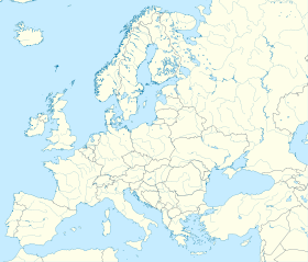

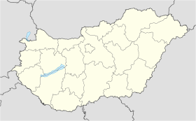
 Mesterszállás


