- Aérodrome de Sha Tin
-
Aérodrome de Sha Tin 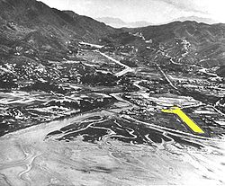
Code AITA Code OACI Localisation Pays  Chine
ChineVille desservie Hong Kong - Sha Tin Coordonnées Pistes Direction Longueur Surface 05/23 600 m (1 969 ft) Dur Informations aéronautiques Gestionnaire Disparu Catégories Aéroports • Aéroports chinois modifier 
L'Aérodrome de Sha Tin était une petite base aérienne de la Royal Air Force située près de Sha Tin dans les Nouveaux Territoires de Hong Kong et définitivement fermée au début des années 1970 alors que la RAF regroupait toutes ses activités sur le terrain de Shek Kong.
Catégories :- Aéroport hongkongais
- Nouveaux Territoires
- Aviation à Hong Kong
- Base de la Royal Air Force


Wikimedia Foundation. 2010.