Vrnograč

Vrnograč

45° 09′ 49″ N 15° 57′ 13″ E / 45.1636, 15.9536

Vrnograč
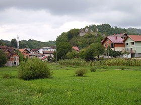
Vue générale Vrnograč
Administration
Pays Drapeau de Bosnie-Herzégovine Bosnie-Herzégovine
Entité Drapeau de la Fédération de Bosnie-et-Herzégovine Fédération de Bosnie-et-Herzégovine
Canton Una-Sana
Municipalité Velika Kladuša
Géographie
Coordonnées 45° 09′ 49″ Nord
       15° 57′ 13″ Est
/ 45.1636, 15.9536
Démographie
Population 1 201 hab. (1991)
Localisation
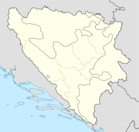
Bosnia and Herzegovina location map.svg
City locator 15.svg
Vrnograč

Vrnograč (en cyrillique : Врнограч) est un village de Bosnie-Herzégovine. Il est situé dans la municipalité de Velika Kladuša et dans le canton d'Una-Sana, Fédération de Bosnie-et-Herzégovine. Au recensement de 1991, il comptait 1 201 habitants, dont une majorité de Musulmans (Bosniaques)[1].

Sommaire

Démographie

Répartition de la population (1991)

Nationalité Nombre %
Musulmans 1 104 91,92
Serbes 37 3,08
Yougoslaves 30 2,49
Croates 10 0,83
Inconnus/autres 20 1,66[1]

En 1991, la communauté locale de Vrnograč comptait 1 773 habitants, répartis de la manière suivante[2] :

Nationalité Nombre %
Musulmans 5 026 97,05
Serbes 55 1,06
Yougoslaves 44 0,85
Croates 13 0,25
Inconnus/autres 41 0,79

Notes et références

  1. a et b (bs)(hr)(sr) Livre : Composition nationale de la population - Résultats de la République par municipalités et localités 1991, Bulletin statistique n°234, Publication de l'Institut national de statistique de Bosnie-Herzégovine, Sarajevo.
  2. (bs)(hr)(sr)[PDF] Recensement par communautés locales sur http://www.fzs.ba, Bosnie-Herzégovine - Fédération de Bosnie-et-Herzégovine - Institut fédéral de statistique. Consulté le 11 octobre 2010

Voir aussi

Sur les autres projets Wikimedia :

Articles connexes

Liens externes


Wikimedia Foundation. 2010.

Contenu soumis à la licence CC-BY-SA. Source : Article Vrnograč de Wikipédia en français (auteurs)

Игры ⚽ Поможем решить контрольную работу

Regardez d'autres dictionnaires:

  • Vrnograc — Original name in latin Vrnogra Name in other language Vrnograc, Vrnogra State code BA Continent/City Europe/Sarajevo longitude 45.16369 latitude 15.95444 altitude 162 Population 6860 Date 2012 02 28 …   Cities with a population over 1000 database

  • Vrnograč — Sp Vrnògračas Ap Vrnograč L Bosnija ir Hercegovina …   Pasaulio vietovardžiai. Internetinė duomenų bazė

  • Velika Kladuša — 45° 11′ 22″ N 15° 48′ 42″ E / 45.1894, 15.8117 …   Wikipédia en Français

  • Druga Liga Federacija Bosne i Hercegovine — The Second League of the Federation of Bosnia and Herzegovina ( Druga liga Federacije Bosne i Hercegovine ) is a football league in Bosnia and Herzegovina. This level is organized in five different leagues Sjever (North), Centar (Center), Jug… …   Wikipedia

  • Bužim — is a village and municipality situated in the most northwestern Bosnia and Herzegovina. Administratively, it is part of the Una Sana Canton.GeographyBužim borders Bosanska Krupa to the east, Cazin to the south, Velika Kladuša to the west and… …   Wikipedia

  • Old town of Visoki — Visoko, Bosnia and Herzegovina Reconstruction of th …   Wikipedia

  • List of settlements in Bosnia and Herzegovina — This is a complete list of settlements in Bosnia and Herzegovina, as recorded by 1991 census, sorted by municipalities. Town of Sarajevo = Sarajevo Centar = • Mrkovići • Nahorevo• Poljine• Radava• Sarajevo (part of settlement)• Vića Sarajevo… …   Wikipedia

  • Velika Kladusa — Velika Kladuša Velika Kladuša Велика Кладуша [[Image:|100px|center|Drapeau]] Blason …   Wikipédia en Français

  • Citadel Počitelj — is a castle in Bosnia and Herzegovina. v …   Wikipedia

  • Fortress of Doboj — Doboj Fortress Doboj, Bosnia and Herzegovina Doboj Fortress …   Wikipedia

Share the article and excerpts

Direct link
Do a right-click on the link above
and select “Copy Link”