Mátyásdomb
- Mátyásdomb
-
Mátyásdomb est un village et une commune du comitat de Fejér en Hongrie.
Géographie
Cette section est vide, insuffisamment détaillée ou incomplète.
Votre aide est la bienvenue !
Histoire
Cette section est vide, insuffisamment détaillée ou incomplète.
Votre aide est la bienvenue !
Catégorie :
- Ville et village du comitat de Fejér
Wikimedia Foundation.
2010.
Contenu soumis à la licence CC-BY-SA. Source : Article Mátyásdomb de Wikipédia en français (auteurs)
Regardez d'autres dictionnaires:
Mátyásdomb — Mátyásdomb … Wikipedia
Fejér — 47°10′0″N 18°35′0″E / 47.16667, 18.58333 … Wikipédia en Français
Mačkovci — Mátyásdomb … Wikipedia
Fejér County — Infobox Hungarian county name =Fejér region =Central Transdanubia seat = Székesfehérvár area = 4359 population = 426,541 density = 98 cities = 108: For the historical county see Fejér (former county). : For the mathematician of the same name see… … Wikipedia
Dunaújváros — The bridge on the Danube … Wikipedia
Mór — For other uses, see Mór (disambiguation). Mór Lamberg Castle, Mór … Wikipedia
Martonvásár — Martonvásár, palace … Wikipedia
Adony — See also: Adony (disambiguation) Adony Adony, church … Wikipedia
Hungarian exonyms (Prekmurje, Slovenia) — The following is a list of Hungarian place names for towns and villages in the Prekmurje region of Slovenia. The hungarian administration in the 19th century few village name was change, mainly old hungarian names (Alsószlavecsa, Mladetincz,… … Wikipedia
Puconci — Puconci … Deutsch Wikipedia


 Hongrie

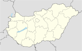
 Mátyásdomb


