Isztimér
- Isztimér
-
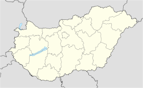
Isztimér est un village et une commune du comitat de Fejér en Hongrie.
Géographie
Cette section est vide, insuffisamment détaillée ou incomplète.
Votre aide est la bienvenue !
Histoire
Cette section est vide, insuffisamment détaillée ou incomplète.
Votre aide est la bienvenue !
Catégorie :
- Ville et village du comitat de Fejér
Wikimedia Foundation.
2010.
Contenu soumis à la licence CC-BY-SA. Source : Article Isztimér de Wikipédia en français (auteurs)
Regardez d'autres dictionnaires:
Isztimér — Isztimér … Deutsch Wikipedia
Isztimer — Isztimer, Marktflecken im Kreise Stuhlweißenburg des Verwaltungsgebietes Pesth Ofen (Ungarn); Weinbau; 1150 Ew … Pierer's Universal-Lexikon
Isztimér — Infobox Settlement subdivision type = Country subdivision name = HUN timezone=CET utc offset=+1 timezone DST=CEST utc offset DST=+2 pushpin pushpin label position = pushpin map caption =Location of Isztimér pushpin mapsize = official… … Wikipedia
Krauchenwies — Wappen Deutschlandkarte … Deutsch Wikipedia
Fejér — 47°10′0″N 18°35′0″E / 47.16667, 18.58333 … Wikipédia en Français
Fejér County — Infobox Hungarian county name =Fejér region =Central Transdanubia seat = Székesfehérvár area = 4359 population = 426,541 density = 98 cities = 108: For the historical county see Fejér (former county). : For the mathematician of the same name see… … Wikipedia
Dunaújváros — The bridge on the Danube … Wikipedia
Mór — For other uses, see Mór (disambiguation). Mór Lamberg Castle, Mór … Wikipedia
Martonvásár — Martonvásár, palace … Wikipedia
Adony — See also: Adony (disambiguation) Adony Adony, church … Wikipedia


 Hongrie

 Isztimér


