Livovská Huta
- Livovská Huta
-
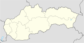
Livovská Huta est un village de Slovaquie situé dans la région de Prešov.
Histoire
La première mention écrite du village date 1773. Le suffixe huta se réfère à un verrerie, située à cet endroit, où fut produit pour la première fois en Hongrie (cf Royaume de Hongrie) du cristal taillé.[3] Les fours de la verrerie étaient alimentés par les bois de Livóhuta (Livovská en slovaque).
Notes et références
Catégories :
- Village de Slovaquie
- Village et ville du district de Bardejov
Wikimedia Foundation.
2010.
Contenu soumis à la licence CC-BY-SA. Source : Article Livovská Huta de Wikipédia en français (auteurs)
Regardez d'autres dictionnaires:
Livovská Huta — is a village and municipality in Bardejov District in the Prešov Region of north east Slovakia.HistoryIn historical records the village was first mentioned in 1773GeographyThe municipality lies at an altitude of 640 metres and covers an area of… … Wikipedia
Huta — (ukrainisch Гута; russisch Guta) ist der Name mehrerer Orte: in Polen: Huta (Bystrzyca Kłodzka) in der Woiwodschaft Niederschlesien Name von 32 Ortschaften, müssen noch ergänzt werden in Rumänien: Dorf im Kreis Cluj, siehe Huta (Cluj) Dorf im… … Deutsch Wikipedia
Stebnícka Huta — (Village) Administration Pays Slovaquie … Wikipédia en Français
List of municipalities and towns in Slovakia — Slovakia This is a comprehensive list of municipalities and towns in Slovakia. For lists of towns and municipalities sorted by Regions see the individual articles on Regions. For an outdated list of towns only in Slovakia see also List of towns… … Wikipedia
Liste der Städte und Gemeinden in der Slowakei/H-Ľ — Übersicht H bis Ľ Teil 1 A bis G Teil 2 H bis Ľ Teil 3 M bis R Teil 4 S bis Ž Übersicht H CH I J K L Ľ H Städte und Gemeinden … Deutsch Wikipedia
Liste der Städte und Gemeinden in der Slowakei Teil 2 — Übersicht H bis Ľ Teil 1 A bis G Teil 2 H bis Ľ Teil 3 M bis R Teil 4 S bis Ž Übersicht H CH I J K L Ľ H Städte und Gemeinden … Deutsch Wikipedia
Prešov Region — Geobox | Region name = Prešov category = Region image caption = image caption = symbol = symbol type = etymology = official name = motto = nickname = country = Slovakia country state = region = district = commune = municipality = border = part… … Wikipedia
Bardejov District — District Country Slovakia Region … Wikipedia
Cigeľka — Location of Bardejov District in the Prešov region Cigeľka is a village and municipality in Bardejov District in the Prešov Region of north east Slovakia with Ruthenian and Roma inhabitants. It lies in the valley of Oľchovec below the Busov hill… … Wikipedia
Dubinné — Location of Bardejov District in the Nitra region Dubinné is a village and municipality in Bardejov District in the Prešov Region of north east Slovakia. History In historical records the village was first mentioned in 1327 … Wikipedia
 Slovaquie
 Livovská Huta