Southern Tablelands
- Southern Tablelands
-
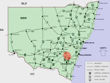
Situation dans la Nouvelle-Galles du Sud
Les Southern Tablelands (en français les plateaux du sud) sont une région non officielle de la Nouvelle-Galles-du-Sud en Australie. La région est située à l'ouest de la Cordillère australienne autour des villes de Yass, Crookwell et Boorowa.
Il s'agit d'un vaste plateau à environ 900 mètres d'altitude qui a été pratiquement complètement déboisé pour faire paître du bétail. La région est facilement accessible à partir de Canberra
Avec les Southern Highlands, la région forme le district touristique connu sous le nom de Capital Country.
Dans un sens plus large, les "Southern Tablelands" regroupent le Monaro, les "Southern Highlands" et Canberra.
Wikimedia Foundation.
2010.
Contenu soumis à la licence CC-BY-SA. Source : Article Southern Tablelands de Wikipédia en français (auteurs)
Regardez d'autres dictionnaires:
Southern Tablelands — The Southern Tablelands is a geographic area of the State of New South Wales, Australia. This area is located west of the Great Dividing Range and includes the towns of Yass, Crookwell and Boorowa. The area is characterised by flat country which… … Wikipedia
Southern Highlands (New South Wales) — Infobox Australian Place | type = region name = Southern Highlands region = Capital Country state = New South Wales lga = Wingecarribee Shire stategov = Goulburn fedgov = Hume near n = Macarthur near ne = Illawarra near e = Illawarra near se =… … Wikipedia
Southern Highlands (Australie) — Hautes Terres du sud Pour les articles homonymes, voir Southern Highlands. Les Hautes Terres du sud en Nouvelle Galles du Sud … Wikipédia en Français
Central Tablelands — The Central Tablelands in New South Wales is an area that is between the Sydney Metropolitan Area and the Central West Slopes and Plains. This area has a part of the Great Dividing Range running through it, including the Blue Mountains. Some… … Wikipedia
Main Southern railway line, New South Wales — [v · New Binalong station on 1916 alignment Gauge: 1,435 mm (4 ft 8 1 … Wikipedia
Hume Highway — Hume Freeway Proposed … Wikipedia
Contenu:Australie — Projet:Australie/Liste des articles Liste mise à jour régulièrement par MyBot (d · c · b) à partir des articles liés au bandeau {{Portail Australie}} Modifications récentes des articles ayant le bandeau de ce portail… … Wikipédia en Français
Regions of New South Wales — In the State of New South Wales, Australia, there are many areas which are commonly known by regional names. Regions are areas that share similar characteristics. These characteristics may be natural such as the Murray River, the coastline, or… … Wikipedia
Great Dividing Range — Coordinates: 25°00′S 147°00′E / 25°S 147°E / 25; 147 … Wikipedia
New South Wales — a state in SE Australia. 5,126,217; 309,433 sq. mi. (801,430 sq. km). Cap.: Sydney. * * * State (pop., 2001: 6,609,304), southeastern Australia. Bounded by Queensland, the Pacific Ocean, Victoria, and South Australia, it has an area of 309,130 sq … Universalium

