- Sankt Veit an der Glan (Bezirk)
-
District de Sankt Veit an der Glan
Sankt Veit an der Glan 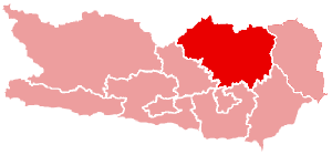
Informations Pays  Autriche
Land  Carinthie
Centre administratif Sankt Veit an der Glan Superficie 1 493,67 km² Population 58 742 hab (15 mai 2001) Densité 39 hab/km² Immatriculation SV Le district de Sankt Veit an der Glan est une subdivision territoriale du land de Carinthie en Autriche.
Sommaire
Géographie
Relief
Lieux administratifs voisins
District de Murau (Land de Styrie) District de Judenburg (Land de Styrie) District de Feldkirchen 
District de Wolfsberg District de Klagenfurt-Land District de Völkermarkt Économie et infrastructures
Communes
Le district de Sankt Veit an der Glan est subdivisé en 20 communes :
- Althofen
- Brückl
- Deutsch-Griffen
- Eberstein
- Frauenstein
- Friesach
- Glödnitz
- Gurk
- Guttaring
- Hüttenberg
- Kappel am Krappfeld
- Klein Sankt Paul
- Liebenfels
- Metnitz
- Micheldorf
- Mölbling
- Sankt Georgen am Längsee
- Sankt Veit an der Glan
- Strassburg
- Weitensfeld im Gurktal
 Portail de l’Autriche
Catégories : District d'Autriche | Carinthie

Wikimedia Foundation. 2010.