Mangrove Cay
- Mangrove Cay
-
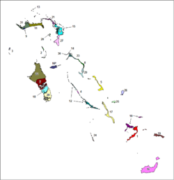
Mangrove Cay est l'un des 32 districts des Bahamas. Il est situé sur l'île Andros et porte le numéro 18 sur la carte.
Sources
Wikimedia Foundation.
2010.
Contenu soumis à la licence CC-BY-SA. Source : Article Mangrove Cay de Wikipédia en français (auteurs)
Regardez d'autres dictionnaires:
Mangrove Cay — The Location of the District of Mangrove Cay Mangrove Cay is one of the districts of the Bahamas, on Andros Island … Wikipedia
Mangrove Cay — Sp Mángrovių salà Ap Mangrove Cay L Bahamose … Pasaulio vietovardžiai. Internetinė duomenų bazė
Mangrove Cay — Admin ASC 1 Code Orig. name Mangrove Cay Country and Admin Code BS.44 BS … World countries Adminstrative division ASC I-II
Mangrove — World mangrove distribution … Wikipedia
Grand Cay — Géographie Pays Bahamas Archipel … Wikipédia en Français
Rum Cay — Géographie Pays Bahamas Archipel … Wikipédia en Français
Great Guana Cay — Location map Bahamas label = Great Guana Cay lat deg = 26 lat min = 40 lat sec = 0 lat dir = N lon deg = 77 lon min = 7 lon sec = 0 lon dir = W caption = Location of Great Guana Cay within the Bahamas float = right width = 250Great Guana Cay is… … Wikipedia
MAY — Mangrove Cay, Bahamas internationale Flughafen Kennung … Acronyms
MAY — Mangrove Cay, Bahamas internationale Fughafen Kennung … Acronyms von A bis Z
List of islands in the Caribbean — This is a list of islands of the Caribbean region, organized by the political territory each island belongs to.Anguilla* Anguilla * Anguillita * Blowing Rock * Cove Cay * Crocus Cay * Deadman s Cay * Dog Island * East Cay * Little Island * Little … Wikipedia
 Bahamas