Lawton (Oklahoma)

Lawton (Oklahoma)
Page d'aide sur l'homonymie Pour les articles homonymes, voir Lawton.

34° 36′ 34″ N 98° 25′ 04″ W / 34.609444, -98.417778

Lawton
Surnom : « L-Town »
Administration
Pays Drapeau des États-Unis États-Unis
État Oklahoma Oklahoma
Comté Comanche
Maire John Purcell
Site web Consulter
Démographie
Population (2006) 109 181 hab.
Densité 561 hab./km²
Géographie
Coordonnées 34° 36′ 34″ Nord
       98° 25′ 04″ Ouest
/ 34.609444, -98.417778
Superficie totale 194,6 km2
· dont terre 194,6 km2 (100 %)
· dont eau 0 km2 (0 %)
Fuseau horaire CST (UTC-6)
Voir la carte administrative
City locator 14.svg
Voir la carte topographique
City locator 14.svg
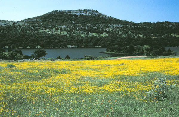
Le mont Scott, au nord de Lawton

Lawton est une ville des États-Unis, siège du comté de Comanche, dans l'Oklahoma. Selon le recensement de 2006, la population de la ville s'élevait à 109 181 habitants, ce qui en fait la quatrième ville de l'Oklahoma après Oklahoma City, Tulsa et Norman.

Le camp militaire de Fort Sill se trouve à proximité de la ville.

Sommaire

Histoire

Le territoire sur lequel est bâtie Lawton a d'abord été attribué aux tribus amérindiennes Comanche, Kiowa et Apache par le traité de Medicine Lodge en 1867. En 1891, le congrès des États-Unis décida de rencontrer les tribus pour parvenir à un accord qui autoriserait la création de colonies américaines. Après des années de luttes juridiques, le président William McKinley prit le contrôle de 8 100 km² pour moins de 2 000 000 de dollars. Sur ce territoire, trois villes furent planifiées pour servir de siège de comté aux trois nouveaux comtés ainsi créés. Lawton fut désignée comme le siège du comté de Comanche et doit son nom à Henry Ware Lawton, officier. À cause de l'instabilité de la région, les villes n'attiraient pas de nouveaux colons. En 1901, une loterie est organisée qui attribue un terrain aux gagnants. Suite à la Première Guerre mondiale, la base militaire de Fort Sill s'agrandit, ce qui entraina une explosion démographique. Après la guerre l'activité économique s'étiola jusqu'à ce que la base militaire de Fort Sill fut choisie pour être le siège de l'U.S. Army Field School en 1930. Depuis lors la croissance démographique de Lawton a été constante.

Géographie

Lawton se trouve dans le sud-ouest de l'Oklahoma, au sud des montagnes Wichita, à 142 km au sud-ouest d'Oklahoma City.

Transport

Lawton est desservie par l'Interstate 44 qui la relie à Oklahoma City au nord-est et à Wichita Falls au sud-ouest. L'aéroport régional de Lawton-Fort Sill (code AITA : LAW, code OACI : KLAW) dessert les villes de Dallas et Atlanta.

Personnalités originaires de la ville

Lien externe

Drapeau de l'Oklahoma
État de l'Oklahoma
Oklahoma City (capitale)
Matières

Villes | Gouvernement | Histoire | Parcs d'État

Villes

Bartlesville | Broken Arrow | Edmond | Enid | Lawton | Midwest City | Moore | Muskogee | Norman | Oklahoma City | Stillwater | Tulsa |

Régions

Arklatex | Central | Cherokee Outlet | Cross Timbers | Four State Area | Flint Hills | Green Country | Kiamichi Country | Little Dixie | Oklahoma City Metro | Montagnes Ouachita | The Ozarks | Panhandle |

Comtés

Adair | Alfalfa | Atoka | Beaver | Beckham | Blaine | Bryan | Caddo | Canadian | Carter | Cherokee | Choctaw | Cimarron | Cleveland | Coal | Comanche | Cotton | Craig | Creek | Custer | Delaware | Dewey | Ellis | Garfield | Garvin | Grady | Grant | Greer | Harmon | Harper | Haskell | Hughes | Jackson | Jefferson | Johnston | Kay | Kingfisher | Kiowa | Latimer | Le Flore | Lincoln | Logan | Love | Major | Marshall | Mayes | McClain | McCurtain | McIntosh | Murray | Muskogee | Noble | Nowata | Okfuskee | Oklahoma | Okmulgee | Osage | Ottawa | Pawnee | Payne | Pittsburg | Pontotoc | Pottawatomie | Pushmataha | Roger Mills | Rogers | Seminole | Sequoyah | Stephens | Texas | Tillman | Tulsa | Wagoner | Washington | Washita | Woods | Woodward


Wikimedia Foundation. 2010.

Contenu soumis à la licence CC-BY-SA. Source : Article Lawton (Oklahoma) de Wikipédia en français (auteurs)

Игры ⚽ Нужна курсовая?

Regardez d'autres dictionnaires:

  • Lawton (Oklahoma) — Lawton Ciudad de los Estados Unidos Ubicación en el condado de Comanche …   Wikipedia Español

  • Lawton, Oklahoma — Infobox Settlement official name = Lawton, Oklahoma settlement type = City nickname = postal code type = ZIP codes postal code = 73500 73599 area code = 580 blank name = FIPS code blank info = 40 41850GR|2 blank1 name = GNIS feature ID blank1… …   Wikipedia

  • Lawton (Oklahoma) — Lawton Spitzname: L Town Namensgeber der Stadt: Henry Ware Lawton Lage in Oklahoma …   Deutsch Wikipedia

  • Eisenhower High School (Lawton, Oklahoma) — Eisenhower Senior High School (EHS) is one of three public high schools located in Lawton, Oklahoma, the others being Lawton High School and MacArthur High School. Its mascot is the Bald Eagle, and its school colors are Colombia Blue, Red, and… …   Wikipedia

  • Lawton-Fort Sill Cavalry — Founded 1990 League CBA 1990 1997 CBA 2007 2009 PBL …   Wikipedia

  • Oklahoma Educational Television Authority — statewide Oklahoma Branding OETA Slogan The Oklahoma Network Channels Analog: see table below Digital …   Wikipedia

  • Lawton-Fort Sill Cavalry — Liga CBA (1990 1997 2007 2009) PBL (2010 Presente) Fundado 1990 …   Wikipedia Español

  • Oklahoma Highway Patrol — Abbreviation OHP Patch of the Oklahoma Highway Patrol …   Wikipedia

  • Lawton — puede referirse a: Lugares Lawton (Dakota del Norte), ciudad en el condado de Ramsey, estado estadounidense de Dakota del Norte. Municipio de Lawton (Dakota del Norte), municipio ubicado en el condado de Ramsey en el estado estadounidense de de… …   Wikipedia Español

  • Lawton High School — was the first high school in Lawton, Oklahoma. It is located at 601 NW Fort Sill Blvd in Lawton, Oklahoma. Its school mascot is the Wolverine. During the early 1960 s, Lawton High School athletic teams won state championships in 5 sports in 1962… …   Wikipedia

Share the article and excerpts

Direct link
Do a right-click on the link above
and select “Copy Link”