Langeveen
Contenu soumis à la licence CC-BY-SA. Source : Article Langeveen de Wikipédia en français (auteurs)
Regardez d'autres dictionnaires:
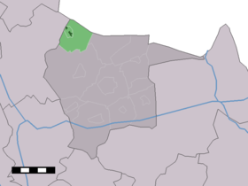
Langeveen — Dutch town locator maps mun town caption = The town centre (dark green) and the statistical district (light green) of Langeveen in the municipality of Tubbergen.Langeveen (coord|52|28|N|6|43|E|type:city(573)) is a town in the Dutch province of… … Wikipedia
Geesteren (Overijssel) — Geesteren Administration Pays Pays Bas Province Overijssel Commune … Wikipédia en Français
Tubbergen — Héraldique … Wikipédia en Français
Tubbergen — Infobox Settlement official name = Tubbergen mapsize = 280px subdivision type = Country subdivision name = Netherlands subdivision type1 = Province subdivision name1 = Overijssel area footnotes = (2006) area total km2 = 147.40 area land km2 = 146 … Wikipedia
List of places in the Netherlands — This is an alphabetical list of places (cities, towns, villages) in the Netherlands. Lists per province can be found at:* List of towns in Groningen * List of towns in Friesland * List of towns in Drente * List of towns in Overijssel * List of… … Wikipedia
Tubbergen — Gemeinde Tubbergen Flagge Wappen Provinz Overijssel Bürgermeister … Deutsch Wikipedia
Albergen — 52° 22′ 18″ N 6° 45′ 43″ E / 52.3717, 6.76194 … Wikipédia en Français
Fleringen — 52°22′54″N 6°48′18″E / 52.38167, 6.805 … Wikipédia en Français
Haarle (Tubbergen) — 52°24′10″N 6°50′23″E / 52.40278, 6.83972 … Wikipédia en Français
Harbrinkhoek — 52°23′7″N 6°43′3″E / 52.38528, 6.7175 … Wikipédia en Français
 Pays-Bas