Iringa (region)
- Iringa (region)
-
Iringa (région)
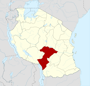
La région d'Iringa est une région du sud la Tanzanie. Elle comprend principalement des zones de hautes terres autour de la ville d'Iringa, sa capitale.
 Portail de la Tanzanie
Catégories : Région d'Iringa | Région de Tanzanie
Wikimedia Foundation.
2010.
Contenu soumis à la licence CC-BY-SA. Source : Article Iringa (region) de Wikipédia en français (auteurs)
Regardez d'autres dictionnaires:
Iringa Region — Iringa is one of Tanzania s 26 administrative regions. The regional capital is Iringa. The total area is 58,936 square kilometers (22,755 square miles), of which land area is 56,864 km sq (21,955 mi sq) and water area is 2,070 km² (800 mi sq).The … Wikipedia
Iringa (région) — Région d Iringa Administration Pays Tanzanie Type Région Capitale Iringa … Wikipédia en Français
Iringa (Region) — Iringa Basisdaten Staat Tansania … Deutsch Wikipedia
Iringa Rural — is one of the 7 districts of the Iringa Region of Tanzania. It is bordered to the North by the Dodoma Region, to the East by the Kilolo and encirclesIringa Urban District, to the South by the Mufindi District, to the Southwest by the Mbeya Region … Wikipedia
Iringa Urban — Iringa Municipality is one of the 7 districts of the Iringa Region of Tanzania. It is bordered to the North by the Iringa Rural District, to the East by the Iringa Rural District, to the South by the Kilolo District, and to the West by the Iringa … Wikipedia
Iringa — Infobox Settlement official name = Iringa other name = native name = nickname = settlement type = motto = imagesize = 300px image caption = Hilltop view of Iringa flag size = image seal size = image shield = shield size = image blank emblem =… … Wikipedia
Iringa — Karte von Tansania, Lage Iringas markiert Straßenscene in Iringa … Deutsch Wikipedia
Région de Kigoma — Localisation de la région de Kigoma en Tanzanie Administration Pays Tanzanie Type … Wikipédia en Français
Iringa — Vue de la ville d Iringa 7°47′6″S 35°41′42″E … Wikipédia en Français
Región de Iringa — Localización de Iringa en el mapa tanzano. Iringa es una de las veintiséis regiones administrativas en las que se encuentra dividida la República Unida de Tanzania. Su ciudad capital es la ciudad de Iringa. Distritos Esta región se encuentra… … Wikipedia Español