Imperial County
- Imperial County
-
Comté d'Imperial
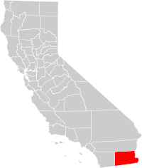
Le comté d'Imperial est un comté de l'État de Californie aux États-Unis. Au recensement de 2000, il comptait 142 361 habitants. Son chef-lieu est El Centro.
Le comté est aride et faiblement peuplé. Il est frontalier de l'Arizona à l'est et du Mexique au sud. Les principales curiosités naturelles sont la Vallée impériale, la Salton Sea, les Dunes Algodones.
Catégorie : Comté de Californie
Wikimedia Foundation.
2010.
Contenu soumis à la licence CC-BY-SA. Source : Article Imperial County de Wikipédia en français (auteurs)
Regardez d'autres dictionnaires:
Imperial County — Courthouse in El Centro Verwaltung US Bundesstaat: Kalifornien … Deutsch Wikipedia
Imperial County — Admin ASC 2 Code Orig. name Imperial County Country and Admin Code US.CA.025 US … World countries Adminstrative division ASC I-II
Imperial County, California — County The fields of Imperial Valley … Wikipedia
Imperial County Airport — Infobox Airport name = Imperial County Airport nativename = Boley Field nativename a = nativename r = image width = caption = IATA = IPL ICAO = KIPL FAA = IPL type = Public owner = operator = Imperial County city served = location = Imperial,… … Wikipedia
Imperial County Arts Council — The Imperial County Arts Council is the official Imperial County, California, USA arts council.The Imperial County Arts Council runs under the California state arts council, the California Arts Council (CAC).Address230 S. 5th StreetEl Centro,… … Wikipedia
San Diego County-Imperial County Regional Communications System — The San Diego County Imperial County Regional Communications System, known locally as the RCS, provides wireless 800 MHz voice (radio) and data communications mdash;on separate networks mdash;to over 200 local, county, state, and federal public… … Wikipedia
Clyde, Imperial County, California — Coordinates: 32°55′00″N 114°57′58″W / 32.9166667°N 114.96611°W / 32.9166667; 114.96611 … Wikipedia
Mayflower, Imperial County, California — Coordinates: 33°03′33″N 115°27′33″W / 33.05917°N 115.45917°W / 33.05917; 115.45917 … Wikipedia
Moss, Imperial County, California — Coordinates: 32°59′52″N 115°24′28″W / 32.99778°N 115.40778°W / 32.99778; 115.40778 … Wikipedia
National Register of Historic Places listings in Imperial County, California — Map of all coordinates from Google Map of all coordinates from Bing … Wikipedia
 États-Unis
