Ilinci

Ilinci
Ilinci
Илинци
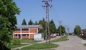
La rue principale d'Ilinici
Administration
Pays Drapeau de Serbie Serbie
Province Voïvodine
Région Syrmie
District Syrmie (Srem)
Municipalité Šid
Code postal 22 250
Géographie
Coordonnées 45° 06′ 49″ Nord
       19° 07′ 29″ Est
/ 45.1136, 19.1247
Altitude 89 m
Superficie 2 820 ha = 28,2 km2
Démographie
Population 827 hab. (2002)
Densité 29,3 hab./km2
Localisation
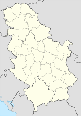
Serbia location map.svg
City locator 14.svg
Ilinci

Ilinci (en serbe cyrillique : Илинци) est un village de Serbie situé dans la province autonome de Voïvodine. Il fait partie de la municipalité de Šid dans le district de Syrmie (Srem). En 2002, il comptait 827 habitants[1], dont une majorité de Serbes.

Sommaire

Démographie

Évolution historique de la population

Évolution démographique
1948 1953 1961 1971 1981 1991 2002
1 335 1 481 1 456 1 198 1 011 883 827[1]

Répartition de la population (2002)

Nationalité Nombre %
Serbes 796 96,25
Yougoslaves 9 1,08
Croates 8 0,96
Slovaques 3 0,36
Hongrois 3 0,36
Musulmans 2 0,24
Macédoniens 2 0,24
Inconnus/Autres[2]

Notes et références

  1. a et b (sr) Livre 9, Population, analyse comparative de la population en 1948, 1953, 1961, 1971, 1981, 1991 et 2002, données par localités, Institut de statistique de la République de Serbie, Belgrade, mai 2004 (ISBN 86-84433-14-9)
  2. (sr) Livre 1, Population, origine nationale ou ethnique, données par localités, Institut de statistique de la République de Serbie, Belgrade, février 2003 (ISBN 86-84433-00-9)

Voir aussi

Sur les autres projets Wikimedia :

Articles connexes

Liens externes


Wikimedia Foundation. 2010.

Contenu soumis à la licence CC-BY-SA. Source : Article Ilinci de Wikipédia en français (auteurs)

Игры ⚽ Поможем написать реферат

Regardez d'autres dictionnaires:

  • Ilinci — (Илинци) is a village in Serbia. It is situated in the Šid municipality, in the Srem District, Vojvodina province. The village has a Serb ethnic majority and its population numbering 827 people (2002 census).NameFormerly, it was known as Sveti… …   Wikipedia

  • Šid — Pour les articles homonymes, voir Sid (homonymie). Šid Шид …   Wikipédia en Français

  • Tvrtko I of Bosnia — Infobox Monarch name=Tvrtko I title=King of Bosnia and later Serbia [Encyclopedia Britannica] caption=Bosnian king Tvrtko Kotromanic with the golden lily on his Crown reign=1353 1391 coronation= 26 October 1377 predecessor=Stephen II… …   Wikipedia

  • Šid — Infobox Serbia municipality native name = Шид|official name=Šid image shield= Sidcoa.gif mayor = Mita Avramov district = Srem area km2 = 687 population total = 16311 mpop = 38973 latd = 45| latm = 07|longd = 19| longm = 14 code = 22 settlements …   Wikipedia

  • Manđelos — Манђелос Settlement Country Serbia District Srem …   Wikipedia

  • List of cities, towns and villages in Vojvodina — This is a list of cities, towns and villages in Vojvodina, a province of Serbia. Largest cities of Vojvodina are: Novi Sad (216,583), Subotica (99,981), Zrenjanin (79,773), Pančevo (77,087), Sombor (51,471), Kikinda (41,935), Sremska Mitrovica… …   Wikipedia

  • Mačvanska Mitrovica — Мачванска Митровица   Town   View …   Wikipedia

  • Novi Slankamen — The Orthodox church …   Wikipedia

  • Mala Remeta — For the monastery located in the village, see Mala Remeta Monastery. Mala Remeta is a village in Serbia. It is situated in the Irig municipality, in the Srem District, Vojvodina province. The village has a Serb ethnic majority and its population… …   Wikipedia

  • Divoš — Дивош Settlement Country Serbia District Srem …   Wikipedia

Share the article and excerpts

Direct link
Do a right-click on the link above
and select “Copy Link”