Hunsruck
- Hunsruck
-
Hunsrück
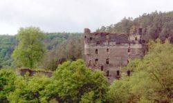
Ruine Balduinseck entre Mastershausen et Buch
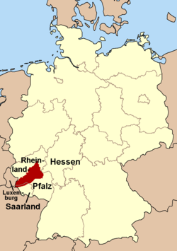
Le Hunsrück est un groupe de montagnes du Rhénanie-Palatinat (Allemagne) faisant partie du massif schisteux rhénan. Il est situé entre la Moselle au nord, le Rhin à l'est, Nahe au sud et la Sarre à l'ouest. Le Hunsrück se situe en face de l'Eifel, de l'autre côté de la Moselle, et du Taunus, sur l'autre rive du Rhin. Le sommet le plus élevé est l’Erbeskopf (816 mètres) dans l’Idarwald.
Film
Voir aussi
 Portail de l’Allemagne
 Portail de la montagne
Catégories : Rhénanie-Palatinat | Massif de montagne de l'Allemagne
Wikimedia Foundation.
2010.
Contenu soumis à la licence CC-BY-SA. Source : Article Hunsruck de Wikipédia en français (auteurs)
Regardez d'autres dictionnaires:
Hunsrück — Ubicación de las Hunsrück en Alemania Ubicación Renania Palatinado … Wikipedia Español
Hunsrück — (Hunsrücken, »hoher Rücken«), 1) ein zwischen Rhein, Mosel, Saar und Nahe in der Rheinprovinz und dem oldenburgischen Fürstentum Birkenfeld gelegenes Gebirge (s. Karte »Rheinprovinz«), durch den Rhein vom Taunus, durch die Mosel von der Eifel und … Meyers Großes Konversations-Lexikon
Hunsrück — (Hundsrücken, d.i. der hohe Rücken), Kalkschieferplateau in der preuß. Rheinprovinz, zwischen Rhein, Mosel, Saar und Nahe, mit den von SW. nach NO. streichenden Waldkämmen des Hochwalds (im Walderbeskopf 816 m hoch), des Idarwalds (Idarkopf 745… … Kleines Konversations-Lexikon
Hunsrück — f1 Hunsrück Lage des Hunsrücks in Deutschland Höchster Gipfel Erbeskopf (816 m … Deutsch Wikipedia
Hunsrück — The Hunsrück is a low mountain range in Rhineland Palatinate, Germany. It is bounded by the river valleys of the Moselle (north), the Nahe (south), and the Rhine (east). The Hunsrück is continued by the Taunus mountains on the eastern side of the … Wikipedia
Hunsrück — 50° 00′ N 7° 30′ E / 50, 7.5 … Wikipédia en Français
Hunsrück — ▪ mountain region, Germany southernmost mountain region of the Rhenish Uplands in central Rhineland Palatinate Land (state), western Germany, bounded by the Rhine (east), Mosel (north), Saar (west), and Nahe (south) rivers. The undulating… … Universalium
Hunsrück — Hụns|rück, der; s: Teil des westlichen Rheinischen Schiefergebirges. * * * Hụnsrück der, der Südwestflügel des Rheinischen Schiefergebirges, in Rheinland Pfalz und im Saarland, erstreckt sich zwischen Rhein, Mosel, Saar und Saar Nahe… … Universal-Lexikon
Hunsrück — Sp Hùnsriukas Ap Hunsrück L kraštovaizdis V Vokietijoje … Pasaulio vietovardžiai. Internetinė duomenų bazė
Hunsrück-Forum — Hunsrück Forum : Zeitschrift für Demokratie Frieden Beschreibung Politikwissenschaft Sprache Deutsch Erstausgabe 1983 … Deutsch Wikipedia
 Allemagne


