Gundagai
- Gundagai
-
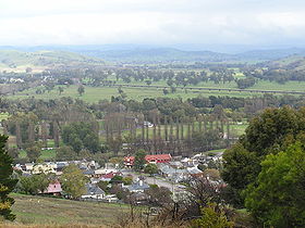
Gundagai (1 998 habitants) est un village sur le Murrumbidgee, à la limite de la Riverina, une région au sud de la Nouvelle-Galles-du-Sud en Australie, à 397 km au sud-ouest de Sydney.
La région était occupée par les Wiradjuri avant l'arrivée des Européens et le nom de la ville est d'origine aborigène, quoique le sens n'en soit pas connu avec précision .
La ville a été plusieurs fois dévastée par les inondations de la rivière. En 1852, quatre aborigènes ont sauvé une quarantaine d'Européens, ce qui a modifié profondément les relations entre les deux populations.
L'économie de la ville est dominée par le tourisme, l'élevage (ovins et bovins), la culture de céréales, luzerne et maïs.
Le sous-sol de la région abrite de l'or et de l'amiante.

Le palais de justice de Gundagai
Références
Statistiques sur Gundagai
Sur les autres projets Wikimedia :
Wikimedia Foundation.
2010.
Contenu soumis à la licence CC-BY-SA. Source : Article Gundagai de Wikipédia en français (auteurs)
Regardez d'autres dictionnaires:
Gundagai — ▪ New South Wales, Australia town, southeastern New South Wales, Australia, on the Murrumbidgee River. The site, originally a sheep run called Willia Ploma, was surveyed in 1838, and the town, a former riverport, derived its present name… … Universalium
Gundagai — Original name in latin Gundagai Name in other language Gundagai State code AU Continent/City Australia/Sydney longitude 35.06525 latitude 148.10802 altitude 239 Population 1704 Date 2012 02 28 … Cities with a population over 1000 database
Gundagai — Admin ASC 2 Code Orig. name Gundagai Country and Admin Code AU.02.13500 AU … World countries Adminstrative division ASC I-II
Gundagai Motel — (Gundagai,Австралия) Категория отеля: 3,5 звезд Адрес: 264 Sheridan Street, 2722 Gund … Каталог отелей
Gundagai, New South Wales — Infobox Australian Place | type = town name = Gundagai state = nsw caption = The town and the Murrumbidgee floodplain in July 2005. The Hume Highway can be seen in the middle distance. lga = Gundagai Shire Council postcode = 2722 pop =… … Wikipedia
Gundagai Shire Council — Infobox Australian Place | type = lga name = Gundagai Shire caption = Location in NSW state=New South Wales region=Riverina area=2458 seat=Gundagai (255 Sheridan Street) cite web title=Gundagai Shire Council publisher = Department of Local… … Wikipedia
Gundagai Shire — Shire of Gundagai Lage des Gundagai Shire in New South Wales Gliederung … Deutsch Wikipedia
gundagai thistle — tikrasis margainis statusas T sritis vardynas apibrėžtis Astrinių šeimos prieskoninis, vaistinis, medingas nuodingas augalas (Silybum marianum), paplitęs šiaurės Afrikoje, pietų Europoje ir pietvakarių Azijoje. Iš jo gaminami maisto priedai… … Lithuanian dictionary (lietuvių žodynas)
Gundagai — /ˈgʌndəgaɪ/ (say gunduhguy) noun a town and shire in south eastern NSW, on the Murrumbidgee River. {Australian Aboriginal} …
Electoral district of Gundagai — Gundagai was a former electoral district for the Legislative Assembly in the Australian state of New South Wales from 1880 to 1904 in the Gundagai area. It was replaced by Wynyard.Members for Gundagai … Wikipedia
 La ville de Gundagai
 Australie
 Gundagai