Gore Highway
- Gore Highway
-

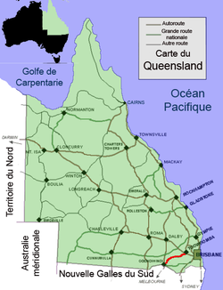
Les principales villes longeant la Gore Highway.
La Gore Highway est un axe routier long de 202 km dans le Queensland en Australie allant de Goondiwindi à Toowoomba. Avec la Goulburn Valley Highway et la Newell Highway, elle fait partie de la National Highway qui relie Melbourne à Brisbane. Elle porte le nom de A39.
Elle traverse la région des Darling Downs avec ses paysages typiques de bétail en pâture, de vergers et de champs de céréales. Elle n'est devenue National Highway que dans les années 1990 en remplacement de la Cunningham Highway pour la portion Goondiwindi - Brisbane, la faisant passer par Toowoomba et la Warrego Highway nouveau tronçon qui présente des pentes moins fortes que l'ancien itinéraire et permettant, en particulier pour les camions, de faire le trajet plus rapidement
Limitation de vitesse
La vitesse est limitée entre:
- Drayton (Toowoomba) et Westbrook à 90 km/h
- Westbrook et Millmerran à 100 km/h
Wikimedia Foundation.
2010.
Contenu soumis à la licence CC-BY-SA. Source : Article Gore Highway de Wikipédia en français (auteurs)
Regardez d'autres dictionnaires:
Gore Highway — Formerly … Wikipedia
Gore Hill Freeway — Formerly … Wikipedia
Gore Pass — Elevation 2,903 m (9,524 ft) Traversed by State Highway 134 … Wikipedia
Gore Orphanage — is the name used by some residents of the greater Cleveland, Ohio, area to refer to a legendary and supposedly haunted ruin near the city of Vermilion in Lorain County, Ohio. The ruin, actually that of the Swift Mansion and later the Light of… … Wikipedia
Gore Range — Mountain Range Country United States State Col … Wikipedia
Gore Motel — Studio album by Bohren der Club of Gore Released 1994 … Wikipedia
Gore Springs, Mississippi — Unincorporated community … Wikipedia
Gore Creek (Colorado) — Gore Creek[1] Origin 39°36′29″N 106°11′43″W / … Wikipedia
Gore Range Trail — is in the Gore Range, part of the Rocky Mountains in the US state of Colorado. It is located in the Eagles Nest Wilderness, Summit County. Buffalo Mountain Trail is north of Interstate 70, west of Highway 9, in Silverthorne. The Gore Range Trail… … Wikipedia
Highway 540 (Ontario) — Highway 540 is a secondary highway on Manitoulin Island in Northern Ontario. At 132 km in length, it is the longest highway on the island. Its eastern terminus is at Highway 6 in the community of Little Current. Its western terminus is the hamlet … Wikipedia

 La Gore Highway.
