Froid (Montana)

Froid (Montana)

48° 20′ 09″ N 104° 29′ 25″ W / 48.335833, -104.490278

Froid
Administration
Pays Drapeau des États-Unis États-Unis
État Montana Montana
Comté Roosevelt
Maire Lee Vannatta[1]
Site web Consulter
Démographie
Population (2000) 195 hab.
Densité 279 hab./km²
Géographie
Coordonnées 48° 20′ 09″ Nord
       104° 29′ 25″ Ouest
/ 48.335833, -104.490278
Altitude 619 m
Superficie totale 0,7 km2
· dont terre 0,7 km2 (100 %)
· dont eau 0 km2 (0 %)
Fuseau horaire MST (UTC-7)
Voir la carte administrative
City locator 14.svg
Voir la carte topographique
City locator 14.svg

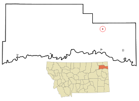
Froid est une petite ville de 195 habitants (en l'année 2000)[2] du comté de Roosevelt, dans le nord-est du Montana (États-Unis). Nommée "Froid" par des explorateurs français dans les années 1600. Connue pour sa production bovine abondante, Froid a le deuxième plus grand nombre de fermes de bœufs en Amérique du nord, juste après Calgary[réf. nécessaire].

Notes et références


Wikimedia Foundation. 2010.

Contenu soumis à la licence CC-BY-SA. Source : Article Froid (Montana) de Wikipédia en français (auteurs)

Игры ⚽ Поможем сделать НИР

Regardez d'autres dictionnaires:

  • Froid (Montana) — Froid Pueblo de los Estados Unidos …   Wikipedia Español

  • Froid, Montana — Infobox Settlement official name = Froid, Montana settlement type = Town nickname = motto = imagesize = image caption = image imagesize = image caption = image mapsize = 250px map caption = Location of Froid, Montana mapsize1 = map caption1 =… …   Wikipedia

  • Montana locations by per capita income — Montana is the forty sixth richest state in the United States of America, with a per capita income of $17,151 (2000). Montana counties ranked by per capita income There are fifty six counties located in Montana, none of which are in the 100… …   Wikipedia

  • Froid — Froid, MT U.S. town in Montana Population (2000): 195 Housing Units (2000): 122 Land area (2000): 0.283381 sq. miles (0.733953 sq. km) Water area (2000): 0.000000 sq. miles (0.000000 sq. km) Total area (2000): 0.283381 sq. miles (0.733953 sq. km) …   StarDict's U.S. Gazetteer Places

  • Froid, MT — U.S. town in Montana Population (2000): 195 Housing Units (2000): 122 Land area (2000): 0.283381 sq. miles (0.733953 sq. km) Water area (2000): 0.000000 sq. miles (0.000000 sq. km) Total area (2000): 0.283381 sq. miles (0.733953 sq. km) FIPS code …   StarDict's U.S. Gazetteer Places

  • Montana Highway 16 — Route information Maintained by MDT Length: 157 mi (253 km) …   Wikipedia

  • List of high schools in Montana — This is a list of high schools in the state of Montana.Beaverhead County*Beaverhead County High School, Dillon *Lima High School, LimaBig Horn County*Hardin High School, Hardin *Lodge Grass High School, Lodge Grass *Plenty Coups High School,… …   Wikipedia

  • Wolf Point, Montana — Wolf Point redirects here. For other uses, see Wolf Point (disambiguation). Wolf Point, Montana   City   Roosevelt County Courthouse in …   Wikipedia

  • Liste der Städte in Montana — Liste der Städte und Ortschaften in Montana, in alphabetischer Reihenfolge. Inhaltsverzeichnis 1 Städte, alphabetisch 2 Die 25 größten Städte Montanas 3 Ortschaften 4 Siehe auch // …   Deutsch Wikipedia

  • Condado de Roosevelt (Montana) — Para otros usos de este término, véase Condado de Roosevelt. Condado de Roosevelt Condado de los Estados Unidos …   Wikipedia Español

Share the article and excerpts

Direct link
Do a right-click on the link above
and select “Copy Link”