Aiga-i-le-Tai
- Aiga-i-le-Tai
-
Wikimedia Foundation.
2010.
Contenu soumis à la licence CC-BY-SA. Source : Article Aiga-i-le-Tai de Wikipédia en français (auteurs)
Regardez d'autres dictionnaires:
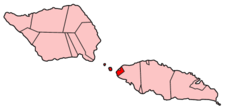
Aiga-i-le-Tai — is a district of Samoa. It is on the western side of Upolu and includes the three small islands in the Apolima Strait (Manono, Apolima, and tiny uninhabited Nuulopa). It surrounds an exclave of A ana district, namely Satuimalufilufi village. The… … Wikipedia
Aiga-i-le-Tai — El texto que sigue es una traducción defectuosa o incompleta. Si quieres colaborar con Wikipedia, busca el artículo original y mejora o finaliza esta traducción. Puedes dar aviso al autor principal del artículo pegando el siguiente código en su… … Wikipedia Español
Aiga i le Tai — Admin ASC 2 Code Orig. name Aiga i le Tai Country and Admin Code WS.02.7669213 WS … World countries Adminstrative division ASC I-II
Aiga-i-le-Tai — Admin ASC 1 Code Orig. name Aiga i le Tai Country and Admin Code WS.02 WS … World countries Adminstrative division ASC I-II
Aiga Rasch — (* 9. Juli 1941 in Stuttgart; † 24. Dezember 2009) war eine deutsche Illustratorin. Inhaltsverzeichnis 1 Leben 2 Die drei ??? 3 Charakterisierung … Deutsch Wikipedia
Manono Island — Manono Satellite image of Manono island with Upolu to the east and tiny Apolima island to the west (NASA photo) Geography … Wikipedia
Mulifanua — Cars wait for the Savai i ferry Mulifanua is a village on the north western tip of the island of Upolu, in Samoa. In the modern era, it is the capital of Aiga i le Tai district. Mulifanua wharf is the main ferry terminal for inter island vehicle… … Wikipedia
Samoa — This article is about the Independent State of Samoa. For the Samoan Archipelago, see Samoan Islands. For U.S. Territory of American Samoa, see American Samoa. For other uses, see Samoa (disambiguation). Malo Sa oloto Tuto atasi o Samoa… … Wikipedia
Nu'ulopa — is a small uninhabited island in the Apolima Strait between the islands of Upolu and Savai i in Samoa. The island is part of Aiga i le Tai district. Nu ulopa is about 50m high. It is also a small forested rocky outcrop with coconut palms (Cocos… … Wikipedia
Manono Uta — is a village on the island of Upolu in Samoa. It is situated on the north west coast of the island in the political district of Aiga i le Tai.[1] The population is 1,358 (2006 Census).[2] See also Manono Island References ^ … Wikipedia