Cite de Parramatta
- Cite de Parramatta
-
Cité de Parramatta
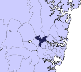
La Cité de Parramatta est une zone d'administration locale dans le centre de Sydney, en Nouvelle-Galles du Sud (Australie).
Banlieues dans la zone d'administration locale
Les quartiers de la Cité de Parramatta sont:
- Camellia
- Clyde
- Constitution Hill
- Dundas
- Dundas Valley
- Eastwood
- Epping
- Ermington
- Granville
- Guildford East
- Harris Park
- Kingsdene
- Merrylands
- Melrose Park
- Northmead
- Old Toongabbie
- Parramatta
- Parramatta North
- Pendle Hill
- Rosehill
- Rydalmere
- South Granville
- Telopea
- Toongabbie
- Winston Hills
- Wentworthville, seulement au nord de la voie de chemin de fer
- Westmead, seulement au nord de la voie de chemin de fer
 Portail de l’Australie
Wikimedia Foundation.
2010.
Contenu soumis à la licence CC-BY-SA. Source : Article Cite de Parramatta de Wikipédia en français (auteurs)
Regardez d'autres dictionnaires:
Cité De Parramatta — Géographie État : Nouvelle Galles du Sud … Wikipédia en Français
Cité de parramatta — Géographie État : Nouvelle Galles du Sud … Wikipédia en Français
Cité de Parramatta — 33°49′S 151°00′E / 33.817, 151 … Wikipédia en Français
Parramatta, New South Wales — ] dist1 = 23 dir1 = west location1 = Sydney CBD lga = City of Parramattacite web|url=http://www.dlg.nsw.gov.au/dlg/dlghome/dlg Regions.asp?regiontype=2 slacode=6250 region=SO|title=Suburb Search Local Council Boundaries Sydney Outer (SO)… … Wikipedia
Parramatta Eels — Infobox rugby league club clubname = Parramatta Eels fullname = Parramatta District Rugby League Football Club nickname = short name = founded = 1947 as Parramatta ground = Parramatta Stadium Parramatta, Sydney capacity = 20,000 ceo = Denis… … Wikipedia
Parramatta railway station, Sydney — Cityrail Station alt|station name=Parramatta| servicearea=Blue Mountains Line|servicearea color=#Blue Mountains line colour|servicearea textcolor=black servicearea2=Cumberland Line|servicearea color2=#Cumberland line colour|servicearea textcolor2 … Wikipedia
Cité de Sydney — 33°52′S 151°12′E / 33.867, 151.2 … Wikipédia en Français
Electoral district of Parramatta — Parramatta is an electoral district of the Legislative Assembly in the Australian state of New South Wales. It is currently held by Tanya Gadiel of the Australian Labor Party, and is not to be confused with the federal Division of Parramatta,… … Wikipedia
The King's School, Parramatta — Infobox Aust school private name = The King s School, Parramatta motto = la. Fortiter et Fideliter (Latin: Bravely and Faithfully )cite web|url = http://www.kings.edu.au/documents/mission04.pdf|title = Mission Statement and Goals 2003… … Wikipedia
Westfield Parramatta — infobox shopping mall shopping mall name = Westfield Parramattа image width = 250 caption = location = opening date = 1975 owner= The Westfield Group manager= developer= number of stores = 456 [ [http://www.westfield.com/parramatta/ourstores/… … Wikipedia