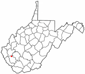
Chapmanville
Contenu soumis à la licence CC-BY-SA. Source : Article Chapmanville de Wikipédia en français (auteurs)
Regardez d'autres dictionnaires:
Chapmanville — may refer to: Chapmanville, a village in Plum Township in Venango County, Pennsylvania Chapmanville, West Virginia This disambiguation page lists articles associated with the same title. If an … Wikipedia
Chapmanville — Chapmanville, WV U.S. town in West Virginia Population (2000): 1211 Housing Units (2000): 658 Land area (2000): 0.673757 sq. miles (1.745022 sq. km) Water area (2000): 0.020492 sq. miles (0.053074 sq. km) Total area (2000): 0.694249 sq. miles… … StarDict's U.S. Gazetteer Places
Chapmanville, WV — U.S. town in West Virginia Population (2000): 1211 Housing Units (2000): 658 Land area (2000): 0.673757 sq. miles (1.745022 sq. km) Water area (2000): 0.020492 sq. miles (0.053074 sq. km) Total area (2000): 0.694249 sq. miles (1.798096 sq. km)… … StarDict's U.S. Gazetteer Places
Chapmanville — Original name in latin Chapmanville Name in other language State code US Continent/City America/New York longitude 37.97371 latitude 82.01735 altitude 197 Population 1256 Date 2011 05 14 … Cities with a population over 1000 database
Chapmanville, West Virginia — Town Location of Chapmanville, West Virginia … Wikipedia
Chapmanville (Virginia Occidental) — Chapmanville Pueblo de los Estados Unidos … Wikipedia Español
Chapmanville Regional High School — is a high school in Chapmanville, West Virginia, United States. The school is unique in the state in that its attendance zone includes students from two counties. When neighboring Lincoln County reduced its four high schools to one, Lincoln… … Wikipedia
25508 — Chapmanville, Wv (Miscellaneous » ZIP Codes) … Abbreviations dictionary
Paroisse de Kent — Pour les articles homonymes, voir Kent (homonymie). Paroisse de Kent Administration Pays … Wikipédia en Français
List of high schools in West Virginia — This is a list of high schools in the U.S. state of West Virginia.Locations are the communities in which they are located, with postal location in parentheses if different.Barbour County*Philip Barbour High School Complex, PhilippiBerkeley… … Wikipedia
 États-Unis
 Virginie-Occidentale