Cetingrad

Cetingrad

Cetingrad

Cetingrad, view from Cetin castle.JPG
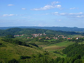
Vue de Cetingrad depuis la forteresse de Cetin

Pays Drapeau de Croatie Croatie
Comitat Karlovac
Population
(municipalité)
2 746 hab. (2001)
Population
(village)
351 hab. (2001)
Superficie
(municipalité)
140 km2
Densité
(municipalité)
19,61 hab./km2
Coordonnées 45° 09′ N 15° 44′ E / 45.15, 15.7345° 09′ Nord
       15° 44′ Est
/ 45.15, 15.73
  
Indicatif téléphonique +385 047
Code postal 47 222
Maire
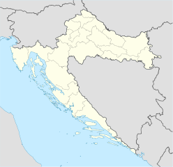
(načelnik)
Nikola Paulić[1] 2005-2009

Géolocalisation sur la carte : Croatie

(Voir situation sur carte : Croatie)
Cetingrad

Cetingrad est un village et une municipalité située dans le comitat de Karlovac, en Croatie. Au recensement de 2001, la municipalité comptait 2 746 habitants, dont 76,66 % de Croates, 9,80,66 % de Bosniaques et 5,28 % de Serbes[2] ; le village seul comptait 351 habitants[3].

Sommaire

Histoire

Localités

La municipalité de Cetingrad compte 36 localités :

  • Batnoga
  • Begovo Brdo
  • Bilo
  • Bogovolja
  • Buhača
  • Cetingrad
  • Cetinski Varoš
  • Delić Poljana
  • Donja Žrvnica
  • Donje Gnojnice
  • Đurin Potok
  • Glinice
  • Gnojnice
  • Gojkovac
  • Gornja Žrvnica
  • Gornje Gnojnice
  • Grabarska
  • Kapljuv
  • Kestenje
  • Komesarac
  • Kruškovača
  • Kuk
  • Luke
  • Maljevac
  • Maljevačko Selište
  • Pašin Potok
  • Podcetin
  • Polojski Varoš
  • Ponor
  • Ruševica
  • Sadikovac
  • Srednje Selo
  • Strmačka
  • Šiljkovača
  • Tatar Varoš
  • Trnovi

Notes et références

  1. (hr) Gouvernement de Croatie, « Adresse et contact de la municipalité » sur vlada.hr. Consulté le 22 janvier 2009
  2. Recensement de 2001 : (en) Population by ethnicity, by towns/municipalities, census 2001 sur dzs.hr, Crostat - Bureau central de statistiques. Consulté le 7 juillet 2008
  3. (en) Population by sex and age by settlements, census 2001 sur dzs.hr, Crostat - Bureau central de statistiques. Consulté le 7 juillet 2008

Voir aussi

Articles connexes

Liens externes


Wikimedia Foundation. 2010.

Contenu soumis à la licence CC-BY-SA. Source : Article Cetingrad de Wikipédia en français (auteurs)

Игры ⚽ Поможем написать реферат

Regardez d'autres dictionnaires:

  • Cetingrad — County Karlovac Location 45°06′N 15°26′E …   Wikipedia

  • Cetingrad — Cetingrad …   Deutsch Wikipedia

  • Cetingrad — Cètingrād m DEFINICIJA selo na Kordunu SI od Slunja, 910 stan. (prije, Cetingrad, pov. Cetin) ONOMASTIKA pr. (etnici): Cètin (150, Z Slavonija), Cètinja (Daruvar), Cètinjan, Cetínjanin (110, Ogulin, Lika), Cetìnskī (Istra) …   Hrvatski jezični portal

  • Cètingrād — m selo na Kordunu SI od Slunja (pov. Cetin) …   Veliki rječnik hrvatskoga jezika

  • Czettin — Burg Cetin DEC …   Deutsch Wikipedia

  • Burg Cetin — p3 Burg Cetin Burg Cetin Ort: Cetingrad Geographische Lage …   Deutsch Wikipedia

  • Liste der Städte in Kroatien — Die kroatischen Gespanschaften Gemeinden in Kroatien Dies ist eine Liste der Orte in Kroatien. Die Liste richtet sich nach den …   Deutsch Wikipedia

  • Orte in Kroatien — Die kroatischen Gespanschaften Gemeinden in Kroatien Dies ist eine Liste der Orte in Kroatien. Die Liste richtet sich nach den …   Deutsch Wikipedia

  • Städte in Kroatien — Die kroatischen Gespanschaften Gemeinden in Kroatien Dies ist eine Liste der Orte in Kroatien. Die Liste richtet sich nach den …   Deutsch Wikipedia

  • Cetin Castle — Cetin The fortress of Cetin The fortress of Cetin is situated 5 kilometres (3.1 mi) south of Cetingrad above the village of Podcetin, in Croatia. The time of foundation of Cetin is unfortunately still u …   Wikipedia

Share the article and excerpts

Direct link
Do a right-click on the link above
and select “Copy Link”