Brookeville
- Brookeville
-
39° 10′ 50″ N 77° 03′ 29″ W / 39.180556, -77.058056
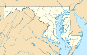
Brookeville est une ville située dans le comté de Montgomery, dans l'État du Maryland, à l'est des États-Unis.
Histoire
La ville fut baptisée par le premier colon, Richard Thomas, du nom de sa femme : Deborah Brooke.
Géographie
Brookeville se trouve à la latitude 39°10'50" Nord, longitude 77°3'29" Ouest.
Démographie
D'après le recensement de 2000, on compte 120 personnes
Liens externes
Sur les autres projets Wikimedia :
Wikimedia Foundation.
2010.
Contenu soumis à la licence CC-BY-SA. Source : Article Brookeville de Wikipédia en français (auteurs)
Regardez d'autres dictionnaires:
Brookeville — Brookeville, MD U.S. town in Maryland Population (2000): 120 Housing Units (2000): 46 Land area (2000): 0.128533 sq. miles (0.332898 sq. km) Water area (2000): 0.000000 sq. miles (0.000000 sq. km) Total area (2000): 0.128533 sq. miles (0.332898… … StarDict's U.S. Gazetteer Places
Brookeville, MD — U.S. town in Maryland Population (2000): 120 Housing Units (2000): 46 Land area (2000): 0.128533 sq. miles (0.332898 sq. km) Water area (2000): 0.000000 sq. miles (0.000000 sq. km) Total area (2000): 0.128533 sq. miles (0.332898 sq. km) FIPS code … StarDict's U.S. Gazetteer Places
Brookeville (Maryland) — Brookeville Brookeville Pays États Unis … Wikipédia en Français
Brookeville, Maryland — Infobox Settlement official name = Brookeville, Maryland settlement type = Town nickname = motto = imagesize = image caption = image imagesize = image caption = image mapsize = 250x200px map caption = Location of Brookeville, Maryland mapsize1 =… … Wikipedia
Clover Hill (Brookeville, Maryland) — Clover Hill U.S. National Register of Historic Places … Wikipedia
20833 — Brookeville, Md (Miscellaneous » ZIP Codes) … Abbreviations dictionary
National Register of Historic Places listings in Montgomery County, Maryland — Location of Montgomery County in Maryland This is a list of the National Register of Historic Places listings in Montgomery County, Maryland. This is intended to be a complete list of the properties and districts on the National Register of… … Wikipedia
Montgomery County, Maryland — Flag … Wikipedia
Maryland Route 97 — This article describes a Maryland state highway numbered 97. For the Interstate with the same number, see Interstate 97. MD 97 redirects here. For the Brazilian assault rifle, see IMBEL MD97 Maryland Route 97 Georgia Avenue, Roxbury Mills Road,… … Wikipedia
Craig Zucker — Member of the Maryland House of Delegates from the 14th district Incumbent Assumed office January 2011 … Wikipedia
 Pour les articles homonymes, voir Brookville.
 États-Unis
 Maryland
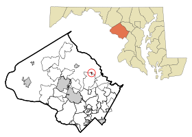


 La Madison House à Brookeville a été construite vers 1800. Le président James Madison y résida le 26 août 1814


