Bronneger
Contenu soumis à la licence CC-BY-SA. Source : Article Bronneger de Wikipédia en français (auteurs)
Regardez d'autres dictionnaires:
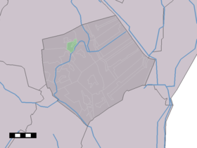
Bronneger — Dutch town locator maps mun town caption = Bronneger in the municipality of Borger Odoorn.Bronneger (coord|52|57|N|6|49|E|type:city(110)) is a hamlet in the Dutch province of Drenthe. It is a part of the municipality of Borger Odoorn, and lies… … Wikipedia
Holiday home Landgoed De Hereboerderij Bronneger — (Bronneger,Нидерланды) Категория отеля: 4 звездочный отель А … Каталог отелей
List of cities, towns and villages in Drenthe — This is a list of settlements in the province of Drenthe, in the Netherlands. Name Municipality Coordinates Aalden Coevorden … Wikipedia
Borger-Odoorn — Pour les articles homonymes, voir Borger. Borger Odoorn … Wikipédia en Français
Canal De Buinen À Schoonoord — Kanaal Buinen Schoonoord Vue sur le canal Caractéristiques Statut actuel Fermé à la navigation Gabarit 60 t … Wikipédia en Français
Canal de Buinen a Schoonoord — Canal de Buinen à Schoonoord Canal de Buinen à Schoonoord Kanaal Buinen Schoonoord Vue sur le canal Caractéristiques Statut actuel Fermé à la navigation Gabarit 60 t … Wikipédia en Français
Canal de Buinen à Schoonoord — Kanaal Buinen Schoonoord Vue sur le canal Caractéristiques Statut actuel Fermé à la navigation Gabarit 60 t … Wikipédia en Français
Canal de buinen à schoonoord — Kanaal Buinen Schoonoord Vue sur le canal Caractéristiques Statut actuel Fermé à la navigation Gabarit 60 t … Wikipédia en Français
Borger-Odoorn — Infobox Settlement official name = Borger Odoorn mapsize = 280px subdivision type = Country subdivision name = Netherlands subdivision type1 = Province subdivision name1 = Drenthe area footnotes = (2006) area total km2 = 277.92 area land km2 =… … Wikipedia
List of places in the Netherlands — This is an alphabetical list of places (cities, towns, villages) in the Netherlands. Lists per province can be found at:* List of towns in Groningen * List of towns in Friesland * List of towns in Drente * List of towns in Overijssel * List of… … Wikipedia
 Pays-Bas