Ľubotín
- Ľubotín
-
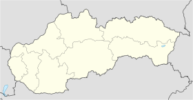
Ľubotín est un village de Slovaquie situé dans la région de Prešov.
Histoire
Première mention écrite du village en 1330.
Notes et références
Catégories :
- Village de Slovaquie
- Village et ville du district de Stará Ľubovňa
Wikimedia Foundation.
2010.
Contenu soumis à la licence CC-BY-SA. Source : Article Ľubotín de Wikipédia en français (auteurs)
Regardez d'autres dictionnaires:
Ľubotín — is a village and municipality in Stará Ľubovňa District in the Prešov Region of northern Slovakia.HistoryIn historical records the village was first mentioned in 1330. The oldest record comes form priest Štefan de Lubentin from the year 1330. It… … Wikipedia
I/68 (Slowakei) — Vorlage:Infobox hochrangige Straße/Wartung/SK I Cesta I. triedy 68 in der Slowakei … Deutsch Wikipedia
I/77 (Slowakei) — Vorlage:Infobox hochrangige Straße/Wartung/SK I Cesta I. triedy 77 in der Slowakei … Deutsch Wikipedia
František Knapík — Ing. František Knapík (* 17 octobre 1956, Ľubotín) est un politicien slovaque au niveau local et régional. Il est maire de Košice depuis le 8 avril 2006 (prochaine élection en 2010). František Knapík est membre du parti KDH. Il est marié et a… … Wikipédia en Français
Коман, Михаил Михайлович — В Википедии есть статьи о других людях с такой фамилией, см. Коман. Михаил Коман … Википедия
Prešov Region — Geobox | Region name = Prešov category = Region image caption = image caption = symbol = symbol type = etymology = official name = motto = nickname = country = Slovakia country state = region = district = commune = municipality = border = part… … Wikipedia
Stará Ľubovňa — Coordinates: 49°18′34″N 20°40′44″E / 49.30944°N 20.67889°E / 49.30944; 20.67889 … Wikipedia
Stará Ľubovňa District — District Country Slovakia Region … Wikipedia
List of municipalities and towns in Slovakia — Slovakia This is a comprehensive list of municipalities and towns in Slovakia. For lists of towns and municipalities sorted by Regions see the individual articles on Regions. For an outdated list of towns only in Slovakia see also List of towns… … Wikipedia
Čirč — Location of Stará Ľubovňa District in the Prešov Region. Čirč is a village and municipality in Stará Ľubovňa District in the Prešov Region of northern Slovakia. History In historical records the village w … Wikipedia
 Slovaquie
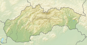
 Ľubotín