Virmajärvi
Contenu soumis à la licence CC-BY-SA. Source : Article Virmajärvi de Wikipédia en français (auteurs)
Regardez d'autres dictionnaires:
Virmajärvi — Infobox lake lake name = Virmajärvi image lake = caption lake = image bathymetry = caption bathymetry = location = coords = coord|62|54|31|N|31|35|11|E|region:FI type:waterbody|display=inline,title type = inflow = outflow = catchment = basin… … Wikipedia
List of lakes in Finland — There are 187,888 lakes in Finland larger than 5 ares (500 square metres). Most are small, but there are 309 lakes or reservoirs larger than 10 km². They are listed here along with some smaller noteworthy lakes.Alphabetical listingAÄhtärinjärvi,… … Wikipedia
Вирмаярви — Virmajärvi Координаты: Координаты … Википедия
Extreme points of the European Union — This is a list of the extreme points of the European Union the points that are farther north, south, east or west than any other location. = As of latest the 5th enlargement (part II) of the European Union on 1st January 2007 = Entire European… … Wikipedia
Extreme points of Finland — This is a list of the extreme points of Finland, the points that are farther north, south, east or west than any other location.*Northernmost Point mdash; Nuorgam, Utsjoki, Lapland coord|70|05|22|N|27|57|45|E|region:FI type:landmark also the… … Wikipedia
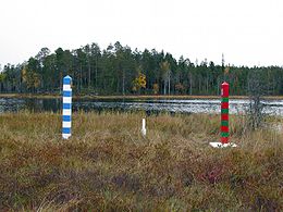
Hattuvaara — is a village in Ilomantsi municipality in the province of Eastern Finland, about 40 km north east from the municipality centre and near the border with Russia.It is the most eastern village in Finland and in the continental part of European Union … Wikipedia
Savitaipale — Savitaipaleen kunta Wappen Karte Basisdaten … Deutsch Wikipedia
Ilomantsi — Géographie Pays Finlande Région Carélie du Nord Altitude … Wikipédia en Français
Liste De Points Extrêmes De L'Union Européenne — Carte du territoire couvert par l Union européenne (en vert) Voici une liste de points extrêmes de l Union européenne. Sommaire 1 … Wikipédia en Français
Liste de points extremes de l'Union europeenne — Liste de points extrêmes de l Union européenne Carte du territoire couvert par l Union européenne (en vert) Voici une liste de points extrêmes de l Union européenne. Sommaire 1 … Wikipédia en Français
 Finlande
 Le lac de Virmajärvi se situe en Finlande orientale.
 Catégories :