2e Valthermond
Contenu soumis à la licence CC-BY-SA. Source : Article 2e Valthermond de Wikipédia en français (auteurs)
Regardez d'autres dictionnaires:
Valthermond — 52°52′30″N 6°56′49″E / 52.875, 6.94694 … Wikipédia en Français
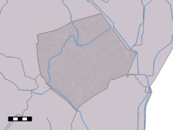
Valthermond — Dutch town locator maps mun town caption = Valthermond in the municipality of Borger Odoorn.Valthermond (coord|52|52|31|N|6|56|56|E|type:city(3580)) is a town in the Dutch province of Drenthe. It is a part of the municipality of Borger Odoorn,… … Wikipedia
Tweede Valthermond — 52°53′35″N 7°1′37″E / 52.89306, 7.02694 … Wikipédia en Français
Tweede Valthermond — Dutch town locator maps mun town caption = Tweede Valthermond in the municipality of Borger Odoorn.Tweede Valthermond (coord|52|54|N|7|2|E|type:city(50)) is a town in the Dutch province of Drenthe. It is a part of the municipality of Borger… … Wikipedia
De Monde — (Valthermond,Нидерланды) Категория отеля: 4 звездочный отель Адрес: 7876GH Valthermond, Нид … Каталог отелей
List of cities, towns and villages in Drenthe — This is a list of settlements in the province of Drenthe, in the Netherlands. Name Municipality Coordinates Aalden Coevorden … Wikipedia
Borger-Odoorn — Gemeinde Borger Odoorn Flagge Wappen Provinz … Deutsch Wikipedia
Borger-Odoorn — Pour les articles homonymes, voir Borger. Borger Odoorn … Wikipédia en Français
Valtherblokken — 52°51′6″N 6°55′14″E / 52.85167, 6.92056 … Wikipédia en Français
Borger-Odoorn — Infobox Settlement official name = Borger Odoorn mapsize = 280px subdivision type = Country subdivision name = Netherlands subdivision type1 = Province subdivision name1 = Drenthe area footnotes = (2006) area total km2 = 277.92 area land km2 =… … Wikipedia
 Pays-Bas
 Portail des Pays-Bas