Tsaghkasar
- Tsaghkasar
-
40° 27′ 58″ N 43° 53′ 59″ E / 40.466111, 43.899722
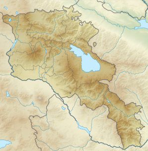
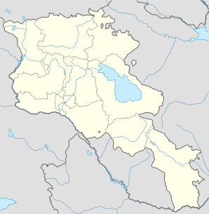
Tsaghkasar ou Tsakhkasar (en arménien Ծաղկասար) est une communauté rurale du marz d'Aragatsotn, en Arménie. Elle compte 127 habitants en 2009[2].
Notes et références
- ↑ (hy+en) Central Electoral Commission of the Republic of Armenia. Consulté le 24 janvier 2011.
Pour obtenir la page en anglais, cliquez sur le drapeau arménien en haut à gauche, et sélectionnez « English » ; ensuite, dans le menu vertical de gauche, cliquez sur « Local », sélectionnez le
marz pertinent, puis la dernière élection correspondant à la communauté voulue.
- ↑ (en) ArmStat, Marzes of the Republic of Armenia in figures, « RA Aragatsotn Marz », 2009. Consulté le 23 novembre 2009.
Catégorie :
- Communauté rurale de l'Aragatsotn
Wikimedia Foundation.
2010.
Contenu soumis à la licence CC-BY-SA. Source : Article Tsaghkasar de Wikipédia en français (auteurs)
Regardez d'autres dictionnaires:
Tsaghkasar — Infobox Settlement official name =Tsaghkasar Ծաղկասար native name = pushpin mapsize =150px subdivision type = Country subdivision name = Armenia subdivision type1 = Marz (Province) subdivision name1 =Aragatsotn leader title = leader name =… … Wikipedia
Oshakan — This article is about a town in Armenia. For the city in Japan, see Osaka. Oshakan Օշական Oshakan as seen from the western side of Didikond Hill … Wikipedia
Aparan — This article is about the town. For the Malayalam film, see Aparan (film). Aparan Panorama of Aparan with Mount Aragats on the right … Wikipedia
Alagyaz — For other places with the same name, see Alagyaz (disambiguation). Coordinates: 40°40′53″N 44°17′25″E / 40.68139°N 44.29028°E / 40.68139; 44.29028 … Wikipedia
Avshen — Coordinates: 40°43′33″N 44°17′30″E / 40.72583°N 44.29167°E / 40.72583; 44.29167 … Wikipedia
Chknagh — Coordinates: 40°35′03″N 44°26′02″E / 40.58417°N 44.43389°E / 40.58417; 44.43389 … Wikipedia
Davtashen, Aragatsotn — For the town in Kotayk Province, see Davtashen, Kotayk. Coordinates: 40°22′N 43°58′E / 40.367°N 43.967°E / 40.367; 43.967 … Wikipedia
Derek, Armenia — Coordinates: 40°42′12″N 44°19′34″E / 40.70333°N 44.32611°E / 40.70333; 44.32611 … Wikipedia
Dian, Armenia — Coordinates: 40°21′10″N 44°04′34″E / 40.35278°N 44.07611°E / 40.35278; 44.07611 … Wikipedia
Ghazaravan — Coordinates: 40°20′52″N 44°20′30″E / 40.34778°N 44.34167°E / 40.34778; 44.34167 … Wikipedia
 Arménie