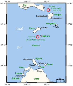
Tongoa

Tongoa
Page d'aide sur l'homonymie Ne doit pas être confondu avec Tangoa.
Tongoa
Cartes des îles Shepherd
Géographie
Pays Drapeau de Vanuatu Vanuatu
Archipel Îles Shepherd
Localisation Océan Pacifique
Coordonnées 16° 54′ S 168° 34′ E / -16.9, 168.5616° 54′ S 168° 34′ E / -16.9, 168.56
Superficie 42,0 km2
Point culminant 487 m
Géologie Île volcanique
Administration
Drapeau de Vanuatu Vanuatu
Province Shefa
Démographie
Population 2 300 hab. (2009)
Densité 54,76 hab./km2
Autres informations
Fuseau horaire UTC+11

Géolocalisation sur la carte : Vanuatu

(Voir situation sur carte : Vanuatu)
Tongoa
Tongoa
Îles du Vanuatu

Tongoa est l’île la plus au nord des îles Shepherd, un archipel du Vanuatu. Avec une superficie de 42,0 km2, c’est aussi la plus grande île de l’archipel[1]. L’île est desservie par un aérodrome (code AITA : TGH).

Population

Tongoa était peuplée en 2009 par 2 300 habitants[2]. Deux langues sont parlées sur l’île : l’éfaté du Nord et le namakura[3].

Références

  1. (en) Îles du Vanuatu. Consulté le 28 octobre 2011
  2. (en) 2009 National Population and Housing Census, Vanuatu National Statistics Office, 2009, p. 12. Consulté le 28 octobre 2011
  3. (en) Languages of Vanuatu, SIL International. Consulté le 28 octobre 2011

Articles connexes


Wikimedia Foundation. 2010.

Contenu soumis à la licence CC-BY-SA. Source : Article Tongoa de Wikipédia en français (auteurs)

Игры ⚽ Нужен реферат?

Regardez d'autres dictionnaires:

  • Tongoa — Vorlage:Infobox Insel/Wartung/Bild fehlt Tongoa (Kuwae) Gewässer Pazifischer Ozean Inselgruppe Shepherd Inseln Geographische Lage …   Deutsch Wikipedia

  • Tongoa Airport — is an airport in Tongoa, Vanuatu (IATA: TGH, ICAO: NVST). Airlines and destinations Air Vanuatu (Port Vila, Valesdir) Coordinates: 16°53′28″S …   Wikipedia

  • TGH — Tongoa, Vanuata internationale Flughafen Kennung …   Acronyms

  • TGH — Tongoa, Vanuata internationale Fughafen Kennung …   Acronyms von A bis Z

  • Islas Shepherd — (Shepherd Islands) Localización geográfica / administrativa Océano (mar) Océano Pacífico Continente (sub) …   Wikipedia Español

  • Shepherd Islands — The Shepherd Islands (coordinates coord|16.8|S|168.5|E) are a group of islands lying between the larger islands of Epi and Éfaté, in the Shefa province of Vanuatu. From north to south, the principal islands are: Laika, Tongoa (Kuwaé), Tongariki,… …   Wikipedia

  • Shepherd-Inseln — Lage der Shepherd Inseln (Provinz Shefa) Gewässer Pazifischer Ozean …   Deutsch Wikipedia

  • Iles Shepherd — Îles Shepherd les îles Shepherd et les volcans sous marins proches Les îles Shepherd (coordonnées …   Wikipédia en Français

  • Îles Shepherd — 16° 48′ S 168° 30′ E / 16.8, 168.5 …   Wikipédia en Français

  • Shefa Province — Shefa is a province of Vanuatu, including the islands of Epi and Efate and the Shepherd Islands. The name Shefa is derived from the initial letters of Shepherd and Efate. It has a population of 45,280 people and an area of 1,455 km². Its capital… …   Wikipedia

Share the article and excerpts

Direct link
Do a right-click on the link above
and select “Copy Link”