- Spantik
-
Spantik 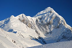
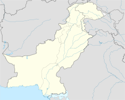
Le Spantik, avec l'arête sud-est à gaucheGéographie Altitude 7 027 m Massif Karakoram Coordonnées Administration Pays  Pakistan
Zone Gilgit-Baltistan Ascension Première 6 juin 1955 par Reiner Diepen, Eduard Reinhardt et Jochen Tietze Voie la plus facile arête sud-est Géolocalisation sur la carte : Pakistan

modifier 
Le Spantik ou Golden Peak est un sommet du Karakoram dans le Nord du Pakistan, qui culmine à 7 027 m d'altitude.
Sommaire
Première ascension
La première tentative d'ascension est faite par William Hunter Workman et sa femme Fanny Bullock Workman en 1903, qui nomment le sommet Pyramid Peak. William Hunter Workman s'arrête à environ 300 mètres sous le sommet, à une altitude qu'il estime à 23 964 pieds (7 309 m), pour laquelle il revendique en 1905 le record d'altitude en alpinisme[1] (le sommet du Spantik n'est en fait qu'à 7 027 m d'altitude).
Le sommet est atteint en 1955 par Reiner Diepen, Eduard Reinhardt et Jochen Tietze lors d'une expédition allemande menée par Karl Kramer.
Le Golden Pillar
 Le Golden Pillar du Spantik
Du 5 au 11 août 1987, les Britanniques Mick Fowler et Victor Saunders, réussissent en style alpin le Golden Pillar en face nord-ouest. Par son esthétique, sa difficulté et le style dans lequel elle a été gravie, c'est l'une des voies de référence présentées dans l'ouvrage d'Andy Fanshawe et Stephen Venables : L'Himalaya en style alpin : les plus belles voies du toit du monde (1996). La voie fait 2 000 m de haut dont 1 100 m et quarante longueurs sur le pilier lui-même.
La voie britannique a été répétée en 2000, en cinq jours, par les Français Emmanuel Guy et Emmanuel Pellissier, le Hongrois Attila Osvath et le Slovène Marko Prezelj. Dans le même temps les russes Mikhail Davy et Alexandre Klenov ont ouvert en 11 jours, une autre voie sur la gauche du pilier, avec des difficultés 7a, A3 et 95°[2].
En 2009, les Japonais Kazuaki Amano, Fumitaka Ichimura et Yusuke Sato ont fait la troisième ascension de la voie britannique, en quatre jours, après avoir tenté une nouvelle voie dans la face à droite du pilier[3].
Annexes
Bibliographie
- Fanny Bullock Workman et William Hunter Workman, Ice-bound heights of the Mustagh : an account of two seasons of pioneer exploration and high climbing in the Baltistan Himalaya, A. Constable & Co., 1908
- Anthony Victor Saunders, « The Golden Pillar », The Himalayan Journal, n° 44, 1986-87
- Anthony Victor Saunders, « The Golden Pillar : Spantik », The American Alpine Journal, The Mountaineers Books, 1997, pp. 21-28
- Mick Fowler, On thin ice: alpine climbs in the Americas, Asia and the Himalaya, Bâton Wicks, 2005
Notes et références
- William Hunter Workman, « Some Obstacles to Himalayan Mountaineering and the History of a Record Ascent », Alpine Journal XXI, août 1905, p. 506
- International Golden Peak Expedition 2000 sur planetmountain.com
- Giri-Giri Boys on Spantik's Golden Pillar sur thebmc.co.uk
Catégories :- Sommet du Pakistan
- Karakoram


Wikimedia Foundation. 2010.