Merthyr Tydfil (county borough)
- Merthyr Tydfil (county borough)
-
County borough de Merthyr Tydfil
(Bwrdeisdref Sirol Merthyr Tudful) |
 |
|
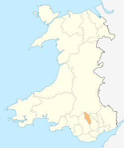
Localisation du comté au Pays de Galles
|
| Administration |
| Pays |
 Royaume-Uni Royaume-Uni |
| Type |
County borough |
| Autres villes |
Merthyr Tydfil |
| Date de création |
1996 |
| ISO 3166-2 |
GB-MTY |
| Géographie |
| Superficie |
111 km2 |
| Population |
| Population |
55 600 hab. (2007) |
| Densité |
500,9 hab./km2 |
Merthyr Tydfil est un comté (County Borough en anglais) située dans le sud du pays de Galles. Son centre administratif se trouve dans la ville homonyme.
Lien externe
Site officiel
Wikimedia Foundation.
2010.
Contenu soumis à la licence CC-BY-SA. Source : Article Merthyr Tydfil (county borough) de Wikipédia en français (auteurs)
Regardez d'autres dictionnaires:
Merthyr Tydfil County Borough Council — (Welsh: Cyngor bwrdeistref Sirol Merthyr Tudful) is the governing body for Merthyr Tydfil, one of the Principal Areas of Wales. Contents 1 Political makeup 1.1 Current composition 1.2 Historic results … Wikipedia
Merthyr Tydfil (UK Parliament constituency) — Merthyr Tydfil Former Borough constituency for the House of Commons 1832 (1832)–1918 (1918) … Wikipedia
Merthyr Tydfil — County Borough Verwaltungssitz Merthyr Tydfil Fläche 111 km² Einwohner 55.700[1] (2009) … Deutsch Wikipedia
Merthyr Tydfil — For the town in Australia, see Merthyr, Queensland. Merthyr Tydfil County Borough Bwrdeisdref Sirol Merthyr Tudful Geography … Wikipedia
County borough — Category Borough Location England and Wales and Ireland Found in Counties Created by Local Government Act 1888 Local Government (Ireland) Act 1898 … Wikipedia
Merthyr Tydfil railway station — Merthyr Tydfil Merthyr Tudful … Wikipedia
Mount Pleasant, Merthyr Tydfil — Mount Pleasant is a small village in the south of Merthyr Tydfil, Wales. It is also known as The Black Lion after the old signal box, controlling, passenger and coal lines from Merthyr Vale Colliery to Cardiff on the Taff Vale Railway. External… … Wikipedia
Merthyr Tydfil — /merr theuhr tid vil/; Welsh /merdd thirdd tud vil/ 1. an administrative district in Mid Glamorgan, in S Wales. 61,500; 43 sq. mi. (113 sq. km). 2. a city in this district. 55,215. * * * ▪ Wales, United Kingdom also spelled Merthyr Tudful … … Universalium
Merthyr Tydfil and Rhymney (UK Parliament constituency) — Not to be confused with Merthyr Tydfil and Rhymney (Assembly constituency). Coordinates: 51°45′07″N 3°18′29″W / 51.752°N 3.308°W … Wikipedia
County Borough of Merthyr Tydfil — Admin ASC 2 Code Orig. name County Borough of Merthyr Tydfil Country and Admin Code GB.WLS.Y3 GB … World countries Adminstrative division ASC I-II
