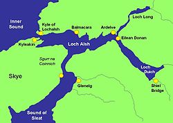
Loch Alsh
Contenu soumis à la licence CC-BY-SA. Source : Article Loch Alsh de Wikipédia en français (auteurs)
Regardez d'autres dictionnaires:
Loch Alsh — Sp Álšo įlanka Ap Loch Alsh angliškai Sp Lòch Álšas Ap Loch Aillse geliškai (škotiškai) L tarp Skajaus s. ir žemyno D. Britanijoje (Škotijoje) … Pasaulio vietovardžiai. Internetinė duomenų bazė
Loch Duich — (Scottish Gaelic: Loch Dubhthaich ) is a sea loch situated on the western coast of Scotland, in the Highlands. It is a popular area for tourists and fishermen. Eilean Donan Castle stands at the meeting point of Loch Duich, Loch Long, and Loch… … Wikipedia
Loch Long (Highlands) — Loch Long is a sea loch situated on the western coast of Scotland, in the Highlands. It is a popular destination for tourists and fishermen.The nearby Eilean Donan Castle stands at the confluence of Loch Long, Loch Duich and Loch Alsh … Wikipedia
Loch Duich — 57.248595 5.483894 Koordinaten: 57° 14′ 55″ N, 5° 29′ 2″ W … Deutsch Wikipedia
Loch Long (Highlands) — Pour les articles homonymes, voir Loch Long. Loch Long Carte du loch Long (en haut à droite) et des lochs environnants … Wikipédia en Français
Loch Long (Highlands) — 57.295834 5.491619 Koordinaten: 57° 17′ 45″ N, 5° 29′ 30″ W … Deutsch Wikipedia
Loch Aillse — Sp Álšo įlanka Ap Loch Alsh angliškai Sp Lòch Álšas Ap Loch Aillse geliškai (škotiškai) L tarp Skajaus s. ir žemyno D. Britanijoje (Škotijoje) … Pasaulio vietovardžiai. Internetinė duomenų bazė
Eilean Donan — Pour les articles homonymes, voir Eilean et Donan. Eilean Donan … Wikipédia en Français
Skye-Bridge — Die Skye Bridge verbindet die Insel Skye mit dem schottischen Hauptland (rechts). Die Skye Bridge (deutsch: Skye Brücke) verbindet Skye, eine Insel der Inneren Hebriden, mit dem schottischen Hauptland. Die Straßenbrücke ist Teil der A87. Sie… … Deutsch Wikipedia
Skye Bridge — Die Skye Bridge verbindet die Insel Skye mit dem schottischen Hauptland (rechts). Die Skye Bridge (deutsch: Skye Brücke) verbindet Skye, eine Insel der Inneren Hebriden, mit dem schottischen Hauptland. Die Straßenbrücke ist Teil der A87. Sie… … Deutsch Wikipedia
 Royaume-Uni
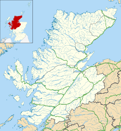


 Portail de l’Écosse
 Portail du monde maritime

