Kondorfa
- Kondorfa
-
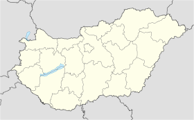
Kondorfa est un village et une commune du comitat de Vas en Hongrie.
Géographie
Cette section est vide, insuffisamment détaillée ou incomplète.
Votre aide est la bienvenue !
Histoire
Cette section est vide, insuffisamment détaillée ou incomplète.
Votre aide est la bienvenue !
Catégorie :
- Ville et village du comitat de Vas
Wikimedia Foundation.
2010.
Contenu soumis à la licence CC-BY-SA. Source : Article Kondorfa de Wikipédia en français (auteurs)
Regardez d'autres dictionnaires:
Kondorfa — Infobox Settlement subdivision type = Country subdivision name = HUN timezone=CET utc offset=+1 timezone DST=CEST utc offset DST=+2|official name=Kondorfa subdivision type1=County subdivision name1=Vas area total km2=21.61 population total=618… … Wikipedia
Vas County — Infobox Hungarian county name =Vas region =Western Transdanubia seat = Szombathely area = 3336 population = 261,900 density = 78 cities = 216Vas (German: Eisenburg , Slovenian Železna županija ) is the name of an administrative county (comitatus… … Wikipedia
Szentgotthárd — City centre with the Rába River … Wikipedia
List of German exonyms for places in Hungary — This is a list of German language exonyms for towns located in Hungary.BudapestOriginal towns: * Buda Ofen * Pest Pesth * Óbuda Alt OfenTowns and villages merged into Budapest in 1950: * Albertfalva Sachsenfeld * Békásmegyer Krottendorf * Budafok … Wikipedia
Csepreg — Sea … Wikipedia
Őriszentpéter — Coat of arms Country … Wikipedia
Kleingebiet Oriszentpeter — Koordinaten fehlen! Hilf mit. Das Kleingebiet Őriszentpéter (ungarisch Őriszentpéteri kistérség) ist eine ungarische Verwaltungseinheit (LAU 1) innerhalb des Komitats Vas. Der Verwaltungssitz ist in Őriszentpéter. Gemeinden Bajánsenye… … Deutsch Wikipedia
Kleingebiet Öriszentpeter — Koordinaten fehlen! Hilf mit. Das Kleingebiet Őriszentpéter (ungarisch Őriszentpéteri kistérség) ist eine ungarische Verwaltungseinheit (LAU 1) innerhalb des Komitats Vas. Der Verwaltungssitz ist in Őriszentpéter. Gemeinden Bajánsenye… … Deutsch Wikipedia
Kleingebiet Őriszentpéter — Das Kleingebiet Őriszentpéter (ungarisch Őriszentpéteri kistérség) ist eine ungarische Verwaltungseinheit (LAU 1) innerhalb des Komitats Vas. Der Verwaltungssitz ist in Őriszentpéter. Gemeinden Bajánsenye Felsőjánosfa Felsőmarác Hegyhátszentjakab … Deutsch Wikipedia
Liste der Gemeinden im Komitat Vas — Diese Liste umfasst die Städte und weitere Orte des Komitats Vas in Ungarn. Städte und Einwohnerzahlen Die Angaben beruhen auf der Volkszählung von 2001. Szombathely: 81.920 Sárvár: 15.519 Körmend: 12.802 Celldömölk: 11.589 Kőszeg: 11.844… … Deutsch Wikipedia


 Hongrie

 Kondorfa


