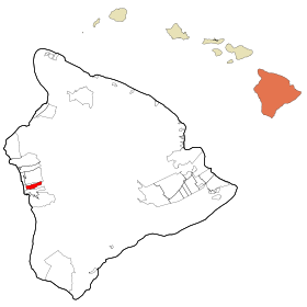
Kealakekua
- Kealakekua
-
Wikimedia Foundation.
2010.
Contenu soumis à la licence CC-BY-SA. Source : Article Kealakekua de Wikipédia en français (auteurs)
Regardez d'autres dictionnaires:
Kealakekua — Lugar designado por el censo de los Estados Unidos … Wikipedia Español
Kealakekua — Kealakekua, HI U.S. Census Designated Place in Hawaii Population (2000): 1645 Housing Units (2000): 692 Land area (2000): 7.542934 sq. miles (19.536108 sq. km) Water area (2000): 0.000000 sq. miles (0.000000 sq. km) Total area (2000): 7.542934 sq … StarDict's U.S. Gazetteer Places
Kealakekua, HI — U.S. Census Designated Place in Hawaii Population (2000): 1645 Housing Units (2000): 692 Land area (2000): 7.542934 sq. miles (19.536108 sq. km) Water area (2000): 0.000000 sq. miles (0.000000 sq. km) Total area (2000): 7.542934 sq. miles… … StarDict's U.S. Gazetteer Places
Kealakekua — Original name in latin Kealakekua Name in other language State code US Continent/City Pacific/Honolulu longitude 19.52083 latitude 155.9225 altitude 445 Population 2019 Date 2011 05 14 … Cities with a population over 1000 database
Kealakekua Bay — Kealakekua Bay. Kealakekua Bay (la « baie de Kealakekua ») est située sur la côte de Kona sur l île de Hawaii (Big Island), à environ 20 kilomètres au sud de Kailua Kona[1]. La région est une zone de conservation de la vie marine … Wikipédia en Français
Kealakekua Bay — [ heiau at Kealakekua Bay, by William Ellis] Kealakekua Bay is located on the Kona coast of the island of Hawai i about 12 miles south of Kailua Kona.cite web | url = http://www.coralreefnetwork.com/reefs/hawaii/kbay/kbay.htm | title = Coral Reef … Wikipedia
Kealakekua, Hawaii — Infobox Settlement official name = Kealakekua, Hawaii other name = native name = nickname = settlement type = CDP motto = imagesize = image caption = flag size = image seal size = image shield = shield size = image blank emblem = blank emblem… … Wikipedia
Kealakekua Bay — geographical name inlet of the Pacific Hawaii in W Hawaii (island) on Kona coast W of Mauna Loa … New Collegiate Dictionary
My Little Grass Shack in Kealakekua, Hawaii — My Little Grass Shack in Kealakekua, Hawaiʻi was a popular song written for the July 4th canoe races in Kona in 1933. Tommy Harrison gave the song to Johnny Noble to publish, who revised the music to give it a new melody without changing Bill… … Wikipedia
96750 — Kealakekua, Hi (Miscellaneous » ZIP Codes) … Abbreviations dictionary
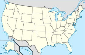
 États-Unis
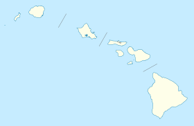
 Hawaï
Hawaï