- Interstate 79
-
Interstate 79 
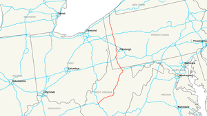
Longueur 552,39 km (343,24 mi) Direction Sud / Nord Extrémité Sud  I-77 à Charleston (Virginie-Occidentale)
Intersections  I-68 à Morgantown (Virginie-Occidentale)
 I-70 à Washington (Pennsylvanie)

 I-76 à Pittsburgh (Pennsylvanie)
 I-80 à Mercer (Pennsylvanie)
 I-90 à Erie (Pennsylvanie)
Extrémité Nord 
 PA-5/PA-290 à Erie
Réseau Interstate highway L'Interstate 79 (ou I-79) est une autoroute inter-États de 552,39 kilomètres de long située aux États-Unis d'Amérique. Elle traverse les États de Virginie-Occidentale et de Pennsylvanie.
Voir aussi
- (en) Cet article est partiellement ou en totalité issu de l’article de Wikipédia en anglais intitulé « Interstate 79 » (voir la liste des auteurs)
Autoroutes inter-États (principales en rose) 
4 5 8 10 12 15 16 17 19 20 22 24 25 26 27 29 30 35 37 39 40 43 44 45 49 55 57 59 64 65 66 68 69 70 71 72 73 74 75 76 (W) 76 (E) 77 78 79 80 81 82 83 84 (W) 84 (E) 85 86 (W) 86 (E) 87 88 (W) 88 (E) 89 90 91 93 94 95 96 97 99 (238) H-1 H-2 H-3 Autres A-1 A-2 A-3 A-4 PRI-1 PRI-2 PRI-3 Catégorie :- Autoroute inter-États américaine


Wikimedia Foundation. 2010.