Đurkovići
- Đurkovići
-
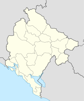
Đurkovići (en serbe cyrillique : Ђурковићи) est un village de l'est du Monténégro, dans la municipalité de Podgorica.
Démographie
Évolution historique de la population
Évolution démographique
(Source : [1])
| 1948 |
1953 |
1961 |
1971 |
1981 |
1991 |
2003 |
| 256 |
241 |
237 |
175 |
156 |
101 |
90 |
Pyramide des âges (2003)
| Pyramide des âges de la ville de Đurkovići |
Pyramide des âges de la ville de Đurkovići en 2003 (population totale : 90)[2] :
| Hommes |
Classe d'âge |
Femmes |
|
2
|
? |
5
|
|
0
|
80 et plus |
4
|
|
2
|
75-79 |
0
|
|
4
|
70-74 |
3
|
|
3
|
65-69 |
4
|
|
2
|
60-64 |
5
|
|
3
|
55-59 |
2
|
|
1
|
50-54 |
4
|
|
4
|
45-49 |
0
|
|
3
|
40-44 |
2
|
|
2
|
35-39 |
4
|
|
1
|
30-34 |
1
|
|
4
|
25-29 |
1
|
|
4
|
20-24 |
2
|
|
4
|
15-19 |
3
|
|
2
|
10-14 |
4
|
|
2
|
5-9 |
1
|
|
1
|
0-4 |
1
|
|
Répartition de la population par nationalités (2003)
Source[3]
Notes et références
- ↑ (sr) Књига 9, Становништво, упоредни преглед броја становника 1948, 1953, 1961, 1971, 1981, 1991, 2003, подаци по насељима, Републички завод за статистику, Подгорица, септембар 2005, COBISS-ID 8764176
- ↑ (sr) Књига 2, Становништво, пол и старост, подаци по насељима, Републички завод за статистику, Подгорица, октобар 2004, COBISS.CG-ID 8489488
- ↑ (sr) Књига 1, Становништво, национална или етничка припадност, подаци по насељима, Републички завод за статистику, Подгорица, септембар 2004, ISBN 86-84433-00-9
Catégories :
- Village du Monténégro
- Localité de Podgorica
Wikimedia Foundation.
2010.
Contenu soumis à la licence CC-BY-SA. Source : Article Đurkovići de Wikipédia en français (auteurs)
Regardez d'autres dictionnaires:
Đurkovići — is a village located just outside of Podgorica, Montenegro and within the territorial boundaries of the Piperi tribe. Categories: PodgoricaMontenegro geography stubs … Wikipedia
Urkovići — 44° 13′ 30″ N 19° 09′ 40″ E / 44.2250, 19.1611 … Wikipédia en Français
Banjani — ( sr. Бањани) is a Old Herzegovinian Serb clan and settlement, today in Montenegro. The Banjani are first mentioned in 1319 in historical documents. Their territory is comprised of 380 km², west of Nikšić.The families of the Banjani clan, by the… … Wikipedia
Bratunac — 44° 11′ 15″ N 19° 20′ 22″ E / 44.1875, 19.3394 … Wikipédia en Français
Podgorica — Vue générale de Podgorica avec le square de St Pierre de Cetinje au premier plan … Wikipédia en Français
Piperi clan — The Piperi tribe (Serbian Cyrillic: Пипери ) is a Serbian clan from Montenegro, originating from the Serb House of Nemanjić, their land is located between the Morača and Zeta rivers, reaching the northern suburbs of Montenegrin capital Podgorica … Wikipedia
List of places in Montenegro — This is a list of all census designated places in Montenegro, sorted by municipalities. Places with more than 1000 residents are in italic .Andrijevica*Andrijevica *Andželati *Bojovići *Božići *Cecuni *Đulići *Dulipolje *Gnjili Potok *Gornje Luge … Wikipedia
List of settlements in Bosnia and Herzegovina — This is a complete list of settlements in Bosnia and Herzegovina, as recorded by 1991 census, sorted by municipalities. Town of Sarajevo = Sarajevo Centar = • Mrkovići • Nahorevo• Poljine• Radava• Sarajevo (part of settlement)• Vića Sarajevo… … Wikipedia
Boljevići (Bratunac) — Pour les articles homonymes, voir Boljevići. 44° 03′ 43″ N 19° 33′ 14″ E … Wikipédia en Français
Dubravice (Bratunac) — Pour les articles homonymes, voir Dubravice. 44° 15′ 50″ N 19° 17′ 18″ E … Wikipédia en Français
 Monténégro