Czarny Staw pod Rysami
- Czarny Staw pod Rysami
-
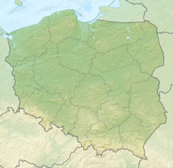
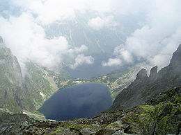
Le Czarny Staw pod Rysami est un lac d’origine glacière des Hautes Tatras. Il est situé sur le versant polonais du massif au pied du mont Rysy et amont du le lac Morskie Oko. Sa surface est de 20,64 ha, sa profondeur de 76,4 m à une altitude de 1 583 m. Son volume d'eau est de 7 761 700 m3 pour une longueur de 578 m et une largueur de 444 m.
Wikimedia Foundation.
2010.
Contenu soumis à la licence CC-BY-SA. Source : Article Czarny Staw pod Rysami de Wikipédia en français (auteurs)
Regardez d'autres dictionnaires:
Czarny Staw pod Rysami — viewed from the southwest, with permanent snowdrift Location Tatra mountains Coordinates … Wikipedia
Tatra (Gebirge) — p1p5 Tatra Luftbild: Blick auf die Hohe Tatra von Norden (Polen) Höchster Gipfel Gerlachovský štít (Gerlsdorfer Spitze) ( … Deutsch Wikipedia
Schwarzer Teich — bezeichnet Černý rybník bei Seiffen in Tschechien Czarny Staw pod Rysami in der Hohen Tatra, Polen Czarny Staw Gąsienicowy, desgleichen Czarny Staw Polski, ebenfalls in der polnischen Tatra Schwarzer Teich (Carlsfeld) bei Carlsfeld in Sachsen und … Deutsch Wikipedia
High Tatras — Vysoké Tatry, Tatry Wysokie Mountain Range … Wikipedia
Hohe Tatra — p1 Hohe Tatra Malá Studená dolina (Hohe Tatra, Slowakische Republik) Höchster Gipfel Gerlachovský štít (Gerlsdorfer Spitze) ( … Deutsch Wikipedia
Hautes Tatras — Pour les articles homonymes, voir Hautes Tatras (homonymie). Hautes Tatras … Wikipédia en Français
Rysy — Le sommet du mont Rysy Géographie Altitude 2 503 m Massif Hautes Tatras (Carpates) … Wikipédia en Français
Liste der Seen in Polen — Seen nach Größe Name Flusssystem Fläche (km²) Tiefe (m) Höhe über Meeresspiegel m ü.NHN Śniardwy (Spirdingsee) Pisa 113,8 23,4 116,1 Mamry (Mauersee) … Deutsch Wikipedia
Poland — Polska redirects here. For other uses, see Polska (disambiguation). This article is about the country. For other uses, see Poland (disambiguation). Republic of Poland Rzeczpospolita Polska … Wikipedia
Cliff — Precipice redirects here. For other uses, see Precipice (disambiguation). Rock face redirects here. For other uses, see Rock face (disambiguation). For other uses, see Cliff (disambiguation). The Trango Towers in Pakistan. Their vertical faces… … Wikipedia
 Pologne