Corydon (Indiana)
- Corydon (Indiana)
-

Pour les articles homonymes, voir
Corydon.
38° 07′ 29″ N 86° 04′ 23″ W / 38.1246, -86.0731
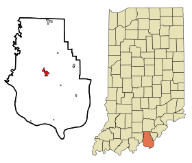
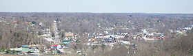
La ville de Corydon se situe dans le sud de l'État de l'Indiana. Elle a été la capitale de l'État de l'Indiana, aux États-Unis, du 1er mai 1813 au 11 décembre 1816, avant que la capitale ne soit déplacée à Indianapolis.
Histoire
Le 9 juillet 1863, durant la Guerre de Sécession, la ville a été le cadre de la bataille de Corydon, remportée par les Confédérés.
Géographie
Cette section est vide, insuffisamment détaillée ou incomplète.
Votre aide est la bienvenue !
Économie
Cette section est vide, insuffisamment détaillée ou incomplète.
Votre aide est la bienvenue !
Notes et références
Liens externes
Sur les autres projets Wikimedia :
Source
v · sièges de comtés de l’État de l’ Indiana  |
|
|
Wikimedia Foundation.
2010.
Contenu soumis à la licence CC-BY-SA. Source : Article Corydon (Indiana) de Wikipédia en français (auteurs)
Regardez d'autres dictionnaires:
Corydon, Indiana — For other uses, see Corydon (disambiguation). Town of Corydon, Indiana Town … Wikipedia
New Corydon, Indiana — New Corydon Town … Wikipedia
Corydon Historic District — U.S. National Register of Historic Places U.S. Historic district … Wikipedia
Corydon Battle Site — U.S. National Register of Historic Places … Wikipedia
Corydon Central High School — is a public high school located in Corydon, Indiana. The school is part of the South Harrison Community School System. The school serves high school age students of Harrison Township, [[Washington Township, Harrison County, Indiana| ], [[Heth… … Wikipedia
Corydon Central Junior High School — is a middle school serving grades 7 8 located in Corydon, Indiana. The school is part of the South Harrison Community School System. The school is built adjacent the Corydon Central High School. During the 2007 2008 school year the school had an… … Wikipedia
Corydon — can be: Contents 1 In literature 2 People 3 Places 4 Other 5 See also … Wikipedia
Corydon — ist die Bezeichnung mehrerer Orte in den Vereinigten Staaten: Corydon (Indiana) Corydon (Iowa) Corydon (Kentucky) Corydon Township (Iowa) Corydon Township (Pennsylvania) Corydon ist der Familienname von: Bjarne Corydon (* 1973), dänischer… … Deutsch Wikipedia
Indiana locations by per capita income — Indiana has the twenty seventh highest per capita income in the United States of America, at $20,397 (2000). Its personal per capita income is $28,783 (2003).Indiana Counties Ranked by Per Capita IncomeThere are ninety two counties located in… … Wikipedia
Indiana Statehouse — Infobox nrhp | name =Indiana Statehouse nrhp type = caption =Indiana State House in Indianapolis location= Indianapolis, Indiana lat degrees = 39 | lat minutes = 46 | lat seconds = 6.95 | lat direction = N long degrees = 86 | long minutes = 9 |… … Wikipedia
 États-Unis
 Indiana