Cancuen
- Cancuen
-
16° 00′ 00″ N 89° 56′ 00″ W / 16, -89.933333

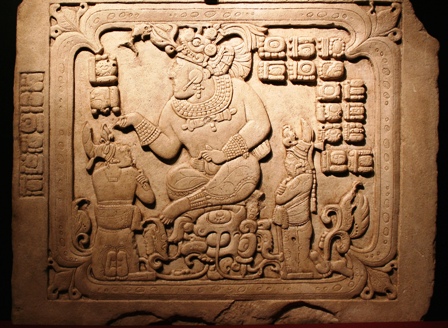
Enseigne représentant le roi T'ah 'ak' Cha'an
Cancuen, qui signifie en maya ancien « place du serpent », est un site archéologique maya découvert en 1905 dans le nord du Guatemala par l'explorateur autrichien Teobert Maler. Il fut sans doute l'un des plus importants centres commerciaux du monde maya. On pense que la cité aurait attiré plusieurs milliers de marchands en provenance des villages voisins, ainsi que de la cité de Tikal, située à 137 km au nord-est de Cancuen.
Une équipe d'archéologues a exhumé des ruines de la cité des centaines d'os, ainsi que des bijoux et des objets de valeur. Il s'agirait des restes des membres de la famille royale, dont le roi et la reine, qui auraient été exécutés lors d'une révolution de palais ou d'un soulèvement populaire, aux environs de l'an 800 de notre ère.
Catégories :
- Site archéologique du Guatemala
- Site archéologique maya
Wikimedia Foundation.
2010.
Contenu soumis à la licence CC-BY-SA. Source : Article Cancuen de Wikipédia en français (auteurs)
Regardez d'autres dictionnaires:
Cancuén — is an archaeological site of the pre Columbian Maya civilization, located in the Pasión subregion of the central Maya lowlands in the present day Guatemalan Department of El Petén. The city is notable for having one of the largest palaces in the… … Wikipedia
Cancuén — Saltar a navegación, búsqueda Panel 3 de Cancuén, mostrando al Rey T ah ak Cha an. Cancuén es un importante sitio maya del período Clásico, que se localiza en la región sur de Sayaxché, Petén, Guatemala, que fue ocupado desde el 300 al … Wikipedia Español
Anthropology and Archaeology — ▪ 2009 Introduction Anthropology Among the key developments in 2008 in the field of physical anthropology was the discovery by a large interdisciplinary team of Spanish and American scientists in northern Spain of a partial mandible (lower… … Universalium
Cultura maya — Extensión del área maya y su localización en el globo terrestre … Wikipedia Español
Sayaxché — Bandera … Wikipedia Español
Dos Pilas — Coordinates: 16°26′45″N 90°17′45″W / 16.44583°N 90.29583°W / 16.44583; 90.29583 … Wikipedia
Machaquila — Machaquilá refers to a ruined city of the Maya civilization in what is now the El Peten department of Guatemala. There is also a small Guatemalan village several kilometers from the site that bears the name Machaquilá. HistoryMachaquilá… … Wikipedia
Kan Maax — (fl. 800 CE), alternatively transliterated as K an Maax, has been identified as the last known ruler of Cancuen, a pre Columbian Maya polity located at the headwaters of the Pasion River in modern day Guatemala. In 2005 an archaeological project… … Wikipedia
Tajal Chan Ahk — Tajal Chan Ahk, also T ah ak Cha an, was an 8th century ruler of the Maya city Cancuén, whose rule lasted from 757 to ca. 799.References: cite book |author=aut|Demarest, Arthur A. |authorlink=Arthur Demarest |year=2006 |title=The Petexbatun… … Wikipedia
Mesoamerican chronology — divides the history of pre Columbian Mesoamerica into several periods: the Paleo Indian (first human habitation–3500 BCE), the Archaic (3500–2000), the Preclassic (2000 BCE–200 CE), the Classic (200 CE–1000CE), and the Postclassic (1000 CE–1697… … Wikipedia