- Aéroport international de Tachkent
-
Aéroport international de Tachkent (Yuzhniy) Toshkent Xalqaro Aeroporti (Janubiy) Международный Аэропорт Ташкента (Южный)
Code AITA Code OACI TAS UTTT Localisation Pays  Ouzbékistan
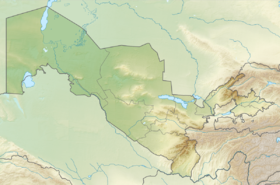
Ville desservie Tachkent Coordonnées Altitude 432 m (1 417 ft) Géolocalisation sur la carte : Ouzbékistan

Pistes Direction Longueur Surface 08L/26R 4 000 m (13 123 ft) Béton bitumineux 08R/26L 3 905 m (12 812 ft) Asphalte Informations aéronautiques Type d'aéroport civil Catégories Aéroports • Aéroports ouzbeks modifier 
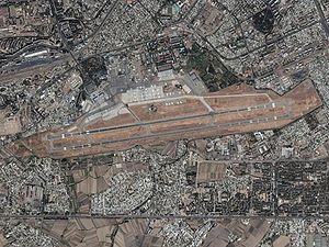
L'aéroport international de Tachkent (Yuzhniy) (en ouzbek: Toshkent Xalqaro Aeroporti (Janubiy), en russe: Международный Аэропорт Ташкента (Южный)) (code AITA : TAS • code OACI : UTTT) est le principal aéroport ouzbek, et le plus grand en Asie centrale. Il dessert la capitale ouzbek Tachkent. Il se situe à une douzaine de kilomètres de son centre. L'aéroport accueille chaque année 2 millions de passagers. Il dispose de 2 terminaux: un pour les vols intérieurs et l'autre pour les vols internationaux.
Compagnies et destinations
- Aeroflot (Moscou-Aéroport international Cheremetievo)
- Air Baltic (Riga)
- Aeroflot-Don (Rostov-sur-le-Don)
- Asiana Airlines (Séoul-Aéroport international d'Incheon)
- Avia Traffic Company (Bichkek)
- China Southern Airlines (Ouroumtchi)
- CSA Czech Airlines (Prague)
- Imair Airlines (Almaty, Bakou)
- Iran Air (Téhéran-Aéroport international Imam Khomeini)
- Korean Air (Séoul-Aéroport international d'Incheon)
- Kuban Airlines (Krasnodar)
- Kyrgyzstan (Bichkek)
- Rossiya (Saint-Pétersbourg)
- S7 Airlines (Irkoutsk, Novossibirsk)
- Tatarstan Airlines (Kazan)
- Transaero (Moscou - Aéroport international Domodiedovo)
- Turkish Airlines (Istamboul-Aéroport international Atatürk)
- Ural Airlines (Ekaterinbourg)
- Uzbekistan Airways (Almaty, Amritsar, Andijan, Achgabat, Astana, Athènes, Bakou, Aéroport Suvarnabhumi de Bangkok, Pékin, Bichkek, Boukhara, Tcheliabinsk, New Delhi, Dubaï, Fergana, Francfort, Genève, Istamboul-Aéroport international Atatürk, Karchi, Kazan, Aéroport de Kiev Boryspil, Krasnodar, Krasnoïarsk, Kuala Lumpur-Sepang, Lahore, Aéroport de Londres Heathrow, Aéroport de Milan Malpensa, Mineralnye Vody, Moscou - Aéroport international Domodiedovo, Namangan, Navoï, New York-Aéroport international John-F.-Kennedy, Novossibirsk, Noukous, Omsk, Osaka-Aéroport international du Kansai, Aéroport Paris-Charles-de-Gaulle, Riga, Aéroport Léonard-de-Vinci de Rome Fiumicino, Rostov-sur-le-Don, Samara, Samarcande, Saint-Pétersbourg, Séoul-Incheon, Charjah, Simferopol, Sotchi, Tel Aviv, Termez, TokyoAéroport international de Narita, Tioumen,Oufa, Ourguentch, Ouroumtchi,Ekaterinbourg, Zeravchan)
- Wind Rose Aviation (Aéroport de Kiev Boryspil)
Voir aussi
Liens externes
- Site officiel
- Tashkent International Airport site internet de Uzbekistan Airways
 La compagnie Uzbekistan Airways constitue la majorité des vols de l'aéroport
 Catégorie :
- Aéroport ouzbek


Wikimedia Foundation. 2010.