Zuilichem
- Zuilichem
-
Zuilichem est un village néerlandais de la commune de Zaltbommel, situé dans la province du Gueldre.
Géographie
Zuilichem est situé à l'ouest de Zaltbommel, sur la rive gauche du Waal, dans la partie nord-ouest du Bommelerwaard.
Histoire
Zuilichem était une commune indépendante jusqu'au 1er juillet 1955, date de son rattachement à la commune de Brakel. Depuis le 1er janvier 1999, le village appartient à la commune de Zaltbommel.
En 1840, la commune comptait 110 maisons et 686 habitants[1].
Référence
- ↑ Alphabetisch register van alle bewoonde oorden des Rijks, Departement van Oorlog, Éd. Erven Doorman, 's-Gravenhage, 1850
Wikimedia Foundation.
2010.
Contenu soumis à la licence CC-BY-SA. Source : Article Zuilichem de Wikipédia en français (auteurs)
Regardez d'autres dictionnaires:
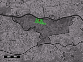
Zuilichem — Dutch town locator maps mun town caption = The village centre (red) and the statistical district (light green) of Zuilichem in the municipality of Zaltbommel.Zuilichem (coord|51|49|N|5|8|E|type:city(764)) is a village in the Dutch province of… … Wikipedia
Bommelerwaard — Situation du Bommelerwaard Le Bommelerwaard est une région naturelle des Pays Bas, située dans le sud ouest de la province du Gueldre. La région a une superficie d environ 147,6 km² et compte environ 48 000 habitants (1999). La circonférence … Wikipédia en Français
Liste der ehemaligen Gemeinden in der Provinz Gelderland — Hierunter folgt eine Liste der ehemaligen gelderschen Gemeinden. Wenn das Gebiet einer aufgehobenen Gemeinde über mehrere Gemeinden verteilt worden ist, ist das Großteil der erstgenannten Gemeinde hinzugefügt. Grenzkorrekturen zwischen erhaltenen … Deutsch Wikipedia
Constantijn Huygens — (1623) Constantijn Huygens (September 4, 1596 – March 28, 1687), was a Dutch Golden Age poet and composer. He was secretary to two Princes of Orange: Frederick Henry and William II, and the father of the scientist Christiaan Huygens … Wikipedia
Zaltbommel — Infobox Settlement official name = Zaltbommel mapsize = 280px subdivision type = Country subdivision name = Netherlands subdivision type1 = Province subdivision name1 = Gelderland area footnotes = (2006) area total km2 = 89.06 area land km2 =… … Wikipedia
Brakel (Gueldre) — 51° 49′ 00″ N 5° 05′ 00″ E / 51.8167, 5.08333 … Wikipédia en Français
Nieuwaal — 51° 48′ 36″ N 5° 10′ 42″ E / 51.81, 5.17833333 … Wikipédia en Français
Kinderdijk — Coordinates: 51°53′N 4°38′E / 51.883°N 4.633°E / 51.883; 4.633 … Wikipedia
List of places in the Netherlands — This is an alphabetical list of places (cities, towns, villages) in the Netherlands. Lists per province can be found at:* List of towns in Groningen * List of towns in Friesland * List of towns in Drente * List of towns in Overijssel * List of… … Wikipedia
De Adriaan, Haarlem — Windmill De Adriaan De Adriaan is a windmill in the Netherlands that burnt down in 1932 and was rebuilt in 2002. The original windmill dates from 1779 and the mill has been a distinctive part of the skyline of Haarlem for centuries. Contents … Wikipedia
 Pays-Bas